Lecture 5: APIs#
Please sign attendance sheet; close devices
APIs#
They are very powerful
Can be used from any programming language
Not expecting you to use them in your Final Project
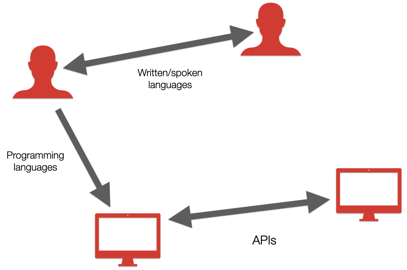
APIs, conceptually#
Talk me through buying a plane ticket.
What are the steps?
What information do you provide?
What do you imagine is happening behind the scenes?
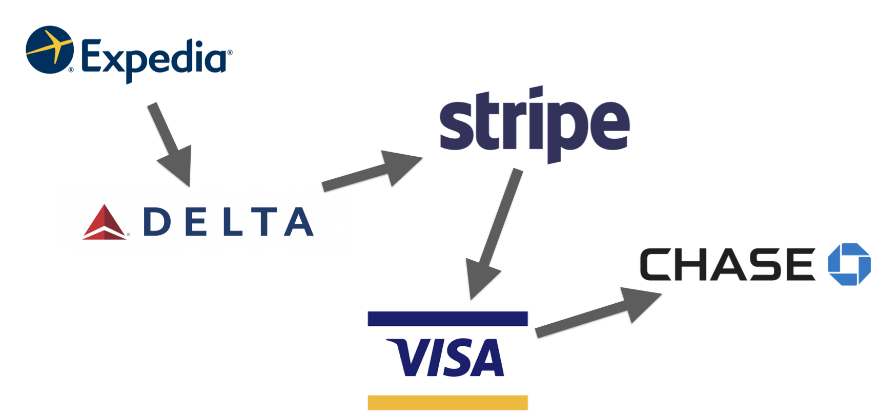
In this example:
Merchant: Expedia/Delta
Payment processor: Stripe
Card network: Visa
Card issuer: Chase
Acquiring bank: ?
interactions between systems ↔️
Ways to get data#
Method |
How it happens |
Pros |
Cons |
|---|---|---|---|
Bulk |
Download, someone hands you a flash drive, etc. |
Fast, one-time transfer |
Can be large; data gets out of date easily |
APIs |
If organization makes one available |
Usually allows some filtering; can always pull latest-and-greatest |
Requires network connection for every call; higher barrier to entry (reading documentation); subject to availability and performance of API |
Scraping |
Data only available through a web site, PDF, or doc |
You can turn anything into data |
Tedious; fragile |
Scraping#
These are open source Python tools, as well as commercial services (with APIs!). Examples:
Web pages#
No-code tools ParseHub
PDFs#
Please pray to the Demo Gods that these all work and there’s no profanity
Wikipedia example#
See Wikipedia’s list of countries by area. How would you turn this into a spreadsheet?
What happens when you want to update it?
Scrape the data#
To comply with Wikimedia’s User-Agent Policy, we need to override the default User-Agent.
Feel free to ignore this part
Blame the AI!
import sys

user_agent = f"PythonPublicPolicyDemo/0.0 (https://python-public-policy.afeld.me/en/nyu/lecture_5.html#scraping; alf9@nyu.edu) Python-urllib/{sys.version_info.major}.{sys.version_info.minor}"
user_agent
'PythonPublicPolicyDemo/0.0 (https://python-public-policy.afeld.me/en/{school_slug}/lecture_5.html#scraping; {email}) Python-urllib/3.12'
import pandas as pd

tables = pd.read_html(
    "https://en.wikipedia.org/wiki/List_of_countries_and_dependencies_by_area",
    match="Country / dependency",
    storage_options={"User-Agent": user_agent},
)
countries = tables[0]
countries
| Unnamed: 0 | Country / dependency | Total in km2 (mi2) | Land in km2 (mi2) | Water in km2 (mi2) | % water | Unnamed: 6 | |
|---|---|---|---|---|---|---|---|
| 0 | – | Earth | 510,072,000 (196,940,000) | 148,940,000 (57,506,000) | 361,132,000 (139,434,000) | 70.8 | NaN |
| 1 | 1 | Russia | 17,098,246 (6,601,667) | 16,376,870 (6,323,142) | 721,380 (278,530) | 4.2 | [b] |
| 2 | – | Antarctica | 14,200,000 (5,480,000) | 14,200,000 (5,480,000) | 0 | 0.0 | [c] |
| 3 | 2 | Canada | 9,984,670 (3,855,100) | 9,093,507 (3,511,021) | 891,163 (344,080) | 8.9 | [d] |
| 4 | 3/4 [e] | China | 9,596,960 (3,705,410) | 9,326,410 (3,600,950) | 270,550 (104,460) | 2.8 | [f] |
| ... | ... | ... | ... | ... | ... | ... | ... |
| 257 | – | Ashmore and Cartier Islands (Australia) | 5.0 (1.9) | 5.0 (1.9) | 0 | 0.0 | [q] |
| 258 | – | Coral Sea Islands (Australia) | 3.0 (1.2) | 3.0 (1.2) | 0 | 0.0 | [da] |
| 259 | – | Spratly Islands (disputed) | 2.0 (0.77) | 2.0 (0.77) | 0 | 0.0 | [54] |
| 260 | 194 | Monaco | 2.0 (0.77) | 2.0 (0.77) | 0 | 0.0 | [db] |
| 261 | 195 | Vatican City | 0.49 (0.19) | 0.49 (0.19) | 0 | 0.0 | [dc] |
262 rows × 7 columns
Data is only available if it’s available#
API calls in the wild#
Go to Candidates page on fec.gov.
Right click and
Inspect.Go to the
Networktab and reload.Filter to
XHR.Click the API call.
We only see this because the tables on fec.gov are rendered client-side using their JSON API. That won’t be the case for all tables on all sites.
Parts of a URL#

For APIs:
Often split into “base URL” + “endpoint”
Endpoints are like function names: they represent the information you are retrieving or thing you are trying to do
Parameters are like function arguments:
They allow options to be specified
Some are required, some are optional
They will differ from one endpoint/function to another
Anchors won’t be used
API documentation#
API calls from Python#
Usually one of two ways:
A software development kit (SDK) like sodapy
Abstracts the details away
Not available for all APIs
May have limitations
The
requestspackage (nothing to do with 311 requests)
Get Jimmy McMillan’s latest candidacy information:
import requests

jimmy = {
    "api_key": "DEMO_KEY",
    "q": "Jimmy McMillan",
    "sort": "-first_file_date",
}
response = requests.get("https://api.open.fec.gov/v1/candidates/", params=jimmy)
data = response.json()
data
{'api_version': '1.0',
 'pagination': {'count': 2,
  'is_count_exact': True,
  'page': 1,
  'pages': 1,
  'per_page': 20},
 'results': [{'active_through': 2016,
   'candidate_id': 'P60016805',
   'candidate_inactive': False,
   'candidate_status': 'N',
   'cycles': [2016, 2018],
   'district': '00',
   'district_number': 0,
   'election_districts': ['00'],
   'election_years': [2016],
   'federal_funds_flag': False,
   'first_file_date': '2015-10-13',
   'has_raised_funds': False,
   'inactive_election_years': None,
   'incumbent_challenge': 'O',
   'incumbent_challenge_full': 'Open seat',
   'last_f2_date': '2015-10-13',
   'last_file_date': '2015-10-13',
   'load_date': '2018-02-17T09:16:20',
   'name': 'MCMILLAN, JIMMY "RENT IS TOO DAMN HIGH',
   'office': 'P',
   'office_full': 'President',
   'party': 'REP',
   'party_full': 'REPUBLICAN PARTY',
   'state': 'US'},
  {'active_through': 2012,
   'candidate_id': 'P60003290',
   'candidate_inactive': False,
   'candidate_status': 'N',
   'cycles': [1996, 1998, 2012, 2020, 2022],
   'district': '00',
   'district_number': 0,
   'election_districts': ['00', '00'],
   'election_years': [1996, 2012],
   'federal_funds_flag': False,
   'first_file_date': '1995-03-08',
   'has_raised_funds': False,
   'inactive_election_years': None,
   'incumbent_challenge': 'C',
   'incumbent_challenge_full': 'Challenger',
   'last_f2_date': '2011-02-07',
   'last_file_date': '2011-02-07',
   'load_date': '2021-12-08T06:50:50',
   'name': 'MCMILLAN, JIMMY (AKA) JAMES ',
   'office': 'P',
   'office_full': 'President',
   'party': 'REP',
   'party_full': 'REPUBLICAN PARTY',
   'state': 'US'}]}
Retrieving nested data#
data["results"][0]["name"]
'MCMILLAN, JIMMY "RENT IS TOO DAMN HIGH'
In-class exercise#
Pair with a neighbor. Open a new notebook in Google Colab, adapt the previous example to retrieve Democratic candidates for President in 2024 who raised funds via the FEC API using Python.
ELT#
Extract-load-transform. You’ll sometimes see “ETL”.
Back to 311 data#
From NYC Open Data Portal dataset page, click Export -> SODA API -> API Docs.
Most open data sites have APIs#
Often built on platforms that provide them, e.g.
NYC Open Data Portal built on Socrata
Various governments use .Stat Suite Data Explorer
Example: 311 requests from the last week#
How would you do this?
The dates shown are from the last time the code was run.
from datetime import datetime, timedelta

now = datetime.utcnow()
now
/var/folders/kr/nx0m1j811kz5vy8c87ffchzr0000gn/T/ipykernel_24194/2825973583.py:3: DeprecationWarning: datetime.datetime.utcnow() is deprecated and scheduled for removal in a future version. Use timezone-aware objects to represent datetimes in UTC: datetime.datetime.now(datetime.UTC).
  now = datetime.utcnow()
datetime.datetime(2025, 10, 22, 15, 51, 58, 176831)
start = now - timedelta(weeks=1)
start
datetime.datetime(2025, 10, 15, 15, 51, 58, 176831)
start.isoformat()
'2025-10-15T15:51:58.176831'
Using the Socrata query language (SoQL):
data_id = "erm2-nwe9"
in_past_week = {
    "$where": f"created_date > '{start.isoformat()}'",
    # just so it's not huge
    "$limit": 100,
}

url = f"https://data.cityofnewyork.us/resource/{data_id}.json"
response = requests.get(url, params=in_past_week)
data = response.json()

data
[{'unique_key': '66488249',
'created_date': '2025-10-15T15:51:59.000',
'closed_date': '2025-10-16T20:58:44.000',
'agency': 'HPD',
'agency_name': 'Department of Housing Preservation and Development',
'complaint_type': 'UNSANITARY CONDITION',
'descriptor': 'PESTS',
'location_type': 'RESIDENTIAL BUILDING',
'incident_zip': '10456',
'incident_address': '1145 CLAY AVENUE',
'street_name': 'CLAY AVENUE',
'address_type': 'ADDRESS',
'city': 'BRONX',
'status': 'Closed',
'resolution_description': "HPD inspected this condition so the complaint has been closed. Violations were issued. The law provides the property owner time to correct the condition(s). Violation descriptions and the dates for the property owner to correct any violations are available at HPDONLINE. If the owner has not corrected the condition by the date provided, you may wish to bring a case in housing court seeking the correction of these conditions.To find out more about how to start a housing court case, visit HPD's w",
'resolution_action_updated_date': '2025-10-16T00:00:00.000',
'community_board': '04 BRONX',
'bbl': '2024290019',
'borough': 'BRONX',
'x_coordinate_state_plane': '1008746',
'y_coordinate_state_plane': '241985',
'open_data_channel_type': 'PHONE',
'park_facility_name': 'Unspecified',
'park_borough': 'BRONX',
'latitude': '40.83083438527125',
'longitude': '-73.91148262087205',
'location': {'latitude': '40.83083438527125',
'longitude': '-73.91148262087205',
'human_address': '{"address": "", "city": "", "state": "", "zip": ""}'}},
{'unique_key': '66495801',
'created_date': '2025-10-15T15:51:59.000',
'closed_date': '2025-10-16T20:58:44.000',
'agency': 'HPD',
'agency_name': 'Department of Housing Preservation and Development',
'complaint_type': 'PAINT/PLASTER',
'descriptor': 'CEILING',
'location_type': 'RESIDENTIAL BUILDING',
'incident_zip': '10456',
'incident_address': '1145 CLAY AVENUE',
'street_name': 'CLAY AVENUE',
'address_type': 'ADDRESS',
'city': 'BRONX',
'status': 'Closed',
'resolution_description': 'The Department of Housing Preservation and Development was unable to access the rooms where the following conditions were reported. No violations were issued. The complaint has been closed.',
'resolution_action_updated_date': '2025-10-16T00:00:00.000',
'community_board': '04 BRONX',
'bbl': '2024290019',
'borough': 'BRONX',
'x_coordinate_state_plane': '1008746',
'y_coordinate_state_plane': '241985',
'open_data_channel_type': 'PHONE',
'park_facility_name': 'Unspecified',
'park_borough': 'BRONX',
'latitude': '40.83083438527125',
'longitude': '-73.91148262087205',
'location': {'latitude': '40.83083438527125',
'longitude': '-73.91148262087205',
'human_address': '{"address": "", "city": "", "state": "", "zip": ""}'}},
{'unique_key': '66495911',
'created_date': '2025-10-15T15:51:59.000',
'closed_date': '2025-10-16T20:58:44.000',
'agency': 'HPD',
'agency_name': 'Department of Housing Preservation and Development',
'complaint_type': 'UNSANITARY CONDITION',
'descriptor': 'PESTS',
'location_type': 'RESIDENTIAL BUILDING',
'incident_zip': '10456',
'incident_address': '1145 CLAY AVENUE',
'street_name': 'CLAY AVENUE',
'address_type': 'ADDRESS',
'city': 'BRONX',
'status': 'Closed',
'resolution_description': "HPD inspected this condition so the complaint has been closed. Violations were issued. The law provides the property owner time to correct the condition(s). Violation descriptions and the dates for the property owner to correct any violations are available at HPDONLINE. If the owner has not corrected the condition by the date provided, you may wish to bring a case in housing court seeking the correction of these conditions.To find out more about how to start a housing court case, visit HPD's w",
'resolution_action_updated_date': '2025-10-16T00:00:00.000',
'community_board': '04 BRONX',
'bbl': '2024290019',
'borough': 'BRONX',
'x_coordinate_state_plane': '1008746',
'y_coordinate_state_plane': '241985',
'open_data_channel_type': 'PHONE',
'park_facility_name': 'Unspecified',
'park_borough': 'BRONX',
'latitude': '40.83083438527125',
'longitude': '-73.91148262087205',
'location': {'latitude': '40.83083438527125',
'longitude': '-73.91148262087205',
'human_address': '{"address": "", "city": "", "state": "", "zip": ""}'}},
{'unique_key': '66495303',
'created_date': '2025-10-15T15:52:00.000',
'agency': 'DOT',
'agency_name': 'Department of Transportation',
'complaint_type': 'Street Light Condition',
'descriptor': 'Lamppost Damaged',
'incident_zip': '11365',
'incident_address': '162 STREET',
'street_name': '162 STREET',
'cross_street_1': '161 STREET',
'cross_street_2': '65 AVENUE',
'address_type': 'BLOCKFACE',
'city': 'QUEENS',
'status': 'Open',
'community_board': '08 QUEENS',
'borough': 'QUEENS',
'open_data_channel_type': 'UNKNOWN',
'park_facility_name': 'Unspecified',
'park_borough': 'QUEENS'},
{'unique_key': '66488892',
'created_date': '2025-10-15T15:52:01.000',
'closed_date': '2025-10-16T00:00:00.000',
'agency': 'DOB',
'agency_name': 'Department of Buildings',
'complaint_type': 'General Construction/Plumbing',
'descriptor': 'Landmark Bldg - Illegal Work',
'incident_zip': '11385',
'incident_address': '60-16 70 AVENUE',
'street_name': '70 AVENUE',
'address_type': 'ADDRESS',
'city': 'RIDGEWOOD',
'facility_type': 'N/A',
'status': 'Closed',
'resolution_description': 'The Department of Buildings investigated this complaint and issued an Office of Administrative Trials and Hearings (OATH) summons.',
'resolution_action_updated_date': '2025-10-16T00:00:00.000',
'community_board': '05 QUEENS',
'bbl': '4035170009',
'borough': 'QUEENS',
'x_coordinate_state_plane': '1012482',
'y_coordinate_state_plane': '194950',
'open_data_channel_type': 'UNKNOWN',
'park_facility_name': 'Unspecified',
'park_borough': 'QUEENS',
'latitude': '40.70172444729474',
'longitude': '-73.89817999017804',
'location': {'latitude': '40.70172444729474',
'longitude': '-73.89817999017804',
'human_address': '{"address": "", "city": "", "state": "", "zip": ""}'}},
{'unique_key': '66496803',
'created_date': '2025-10-15T15:52:01.000',
'closed_date': '2025-10-16T00:00:00.000',
'agency': 'DOB',
'agency_name': 'Department of Buildings',
'complaint_type': 'General Construction/Plumbing',
'descriptor': 'Sidewalk Shed/Pipe Scafford - Inadequate Defective/None',
'incident_zip': '10010',
'incident_address': '210 EAST 21 STREET',
'street_name': 'EAST 21 STREET',
'address_type': 'ADDRESS',
'city': 'NEW YORK',
'status': 'Closed',
'resolution_description': 'The Department of Buildings investigated this complaint and determined that no further action was necessary.',
'resolution_action_updated_date': '2025-10-16T00:00:00.000',
'community_board': '06 MANHATTAN',
'bbl': '1009010052',
'borough': 'MANHATTAN',
'x_coordinate_state_plane': '988797',
'y_coordinate_state_plane': '207906',
'open_data_channel_type': 'UNKNOWN',
'park_facility_name': 'Unspecified',
'park_borough': 'MANHATTAN',
'latitude': '40.73732941517181',
'longitude': '-73.9835922753689',
'location': {'latitude': '40.73732941517181',
'longitude': '-73.9835922753689',
'human_address': '{"address": "", "city": "", "state": "", "zip": ""}'}},
{'unique_key': '66488648',
'created_date': '2025-10-15T15:52:16.000',
'agency': 'DCWP',
'agency_name': 'Department of Consumer and Worker Protection',
'complaint_type': 'Consumer Complaint',
'descriptor': 'Tow Truck Company',
'location_type': 'Business',
'incident_zip': '11207',
'incident_address': '1924 BROADWAY',
'street_name': 'BROADWAY',
'cross_street_1': 'EASTERN PARKWAY',
'cross_street_2': 'STEWART STREET',
'intersection_street_1': 'EASTERN PARKWAY',
'intersection_street_2': 'STEWART STREET',
'address_type': 'ADDRESS',
'city': 'BROOKLYN',
'landmark': 'BROADWAY',
'status': 'In Progress',
'resolution_description': "The Department of Consumer and Worker Protection (DCWP) sent you a complaint form. To help you, DCWP must get the completed form and any requested documents within 30 days. You can send requested information by email, fax, or mail. Contact information is on the complaint form. You may also be able to submit requested information at nyc.gov/dcwp. You must enter your NYC311 Service Request number. If you didn't receive the complaint form within 15 days from the date you filed your Service Request, call DCWP Consumer Services at (212) 487-4110. You must provide your NYC311 Service Request number. DCWP will contact you about 30 days after getting your completed form and documents.",
'resolution_action_updated_date': '2025-10-16T15:24:31.000',
'community_board': '16 BROOKLYN',
'bbl': '3015400072',
'borough': 'BROOKLYN',
'x_coordinate_state_plane': '1010543',
'y_coordinate_state_plane': '186985',
'open_data_channel_type': 'PHONE',
'park_facility_name': 'Unspecified',
'park_borough': 'BROOKLYN',
'latitude': '40.67986834468999',
'longitude': '-73.90520416422301',
'location': {'latitude': '40.67986834468999',
'longitude': '-73.90520416422301',
'human_address': '{"address": "", "city": "", "state": "", "zip": ""}'}},
{'unique_key': '66493894',
'created_date': '2025-10-15T15:52:20.000',
'closed_date': '2025-10-15T17:29:28.000',
'agency': 'NYPD',
'agency_name': 'New York City Police Department',
'complaint_type': 'Noise - Residential',
'descriptor': 'Loud Music/Party',
'location_type': 'Residential Building/House',
'incident_zip': '10466',
'incident_address': '655 EAST 230 STREET',
'street_name': 'EAST 230 STREET',
'cross_street_1': 'CARPENTER AVENUE',
'cross_street_2': 'LOWERRE PLACE',
'intersection_street_1': 'CARPENTER AVENUE',
'intersection_street_2': 'LOWERRE PLACE',
'address_type': 'ADDRESS',
'city': 'BRONX',
'landmark': 'EAST 230 STREET',
'status': 'Closed',
'resolution_description': 'The Police Department responded to the complaint and with the information available observed no evidence of the violation at that time.',
'resolution_action_updated_date': '2025-10-15T17:29:31.000',
'community_board': '12 BRONX',
'bbl': '2048330028',
'borough': 'BRONX',
'x_coordinate_state_plane': '1022911',
'y_coordinate_state_plane': '264242',
'open_data_channel_type': 'MOBILE',
'park_facility_name': 'Unspecified',
'park_borough': 'BRONX',
'latitude': '40.89187241649303',
'longitude': '-73.86016845296459',
'location': {'latitude': '40.89187241649303',
'longitude': '-73.86016845296459',
'human_address': '{"address": "", "city": "", "state": "", "zip": ""}'}},
{'unique_key': '66485975',
'created_date': '2025-10-15T15:52:21.000',
'closed_date': '2025-10-15T15:52:21.000',
'agency': 'DOB',
'agency_name': 'Department of Buildings',
'complaint_type': 'Boilers',
'descriptor': 'Boiler - Defective/Inoperative/No Permit',
'incident_zip': '10029',
'incident_address': '16 EAST 116 ST-MARIN BOULEVARD',
'street_name': 'EAST 116 ST-MARIN BOULEVARD',
'address_type': 'ADDRESS',
'city': 'NEW YORK',
'facility_type': 'N/A',
'status': 'Open',
'resolution_description': 'Your Service Request has been submitted to the Department of Buildings. Please check back later for status.',
'resolution_action_updated_date': '2025-10-15T00:00:00.000',
'community_board': '11 MANHATTAN',
'bbl': '1016210063',
'borough': 'MANHATTAN',
'x_coordinate_state_plane': '999319',
'y_coordinate_state_plane': '230846',
'open_data_channel_type': 'UNKNOWN',
'park_facility_name': 'Unspecified',
'park_borough': 'MANHATTAN',
'latitude': '40.800282069919064',
'longitude': '-73.94557250033134',
'location': {'latitude': '40.800282069919064',
'longitude': '-73.94557250033134',
'human_address': '{"address": "", "city": "", "state": "", "zip": ""}'}},
{'unique_key': '66486401',
'created_date': '2025-10-15T15:52:25.000',
'agency': 'HPD',
'agency_name': 'Department of Housing Preservation and Development',
'complaint_type': 'APPLIANCE',
'descriptor': 'ELECTRIC/GAS RANGE',
'location_type': 'RESIDENTIAL BUILDING',
'incident_zip': '10459',
'incident_address': '1095 PROSPECT AVENUE',
'street_name': 'PROSPECT AVENUE',
'address_type': 'ADDRESS',
'city': 'BRONX',
'status': 'Open',
'resolution_description': 'The following complaint conditions are still open. HPD has already attempted to notify the property owner that the condition exists; the tenant should provide access for the owner to make the repair. HPD may attempt to contact the tenant by phone to verify the correction of the condition or an HPD Inspector may attempt to conduct an inspection.',
'resolution_action_updated_date': '2025-10-15T00:00:00.000',
'community_board': '03 BRONX',
'bbl': '2026800077',
'borough': 'BRONX',
'x_coordinate_state_plane': '1012185',
'y_coordinate_state_plane': '240174',
'open_data_channel_type': 'PHONE',
'park_facility_name': 'Unspecified',
'park_borough': 'BRONX',
'latitude': '40.82585350328034',
'longitude': '-73.89906319332044',
'location': {'latitude': '40.82585350328034',
'longitude': '-73.89906319332044',
'human_address': '{"address": "", "city": "", "state": "", "zip": ""}'}},
{'unique_key': '66486648',
'created_date': '2025-10-15T15:52:25.000',
'agency': 'HPD',
'agency_name': 'Department of Housing Preservation and Development',
'complaint_type': 'PLUMBING',
'descriptor': 'BATHTUB/SHOWER',
'location_type': 'RESIDENTIAL BUILDING',
'incident_zip': '10459',
'incident_address': '1095 PROSPECT AVENUE',
'street_name': 'PROSPECT AVENUE',
'address_type': 'ADDRESS',
'city': 'BRONX',
'status': 'Open',
'resolution_description': 'The following complaint conditions are still open. HPD has already attempted to notify the property owner that the condition exists; the tenant should provide access for the owner to make the repair. HPD may attempt to contact the tenant by phone to verify the correction of the condition or an HPD Inspector may attempt to conduct an inspection.',
'resolution_action_updated_date': '2025-10-15T00:00:00.000',
'community_board': '03 BRONX',
'bbl': '2026800077',
'borough': 'BRONX',
'x_coordinate_state_plane': '1012185',
'y_coordinate_state_plane': '240174',
'open_data_channel_type': 'PHONE',
'park_facility_name': 'Unspecified',
'park_borough': 'BRONX',
'latitude': '40.82585350328034',
'longitude': '-73.89906319332044',
'location': {'latitude': '40.82585350328034',
'longitude': '-73.89906319332044',
'human_address': '{"address": "", "city": "", "state": "", "zip": ""}'}},
{'unique_key': '66487988',
'created_date': '2025-10-15T15:52:25.000',
'agency': 'HPD',
'agency_name': 'Department of Housing Preservation and Development',
'complaint_type': 'DOOR/WINDOW',
'descriptor': 'WINDOW PANE',
'location_type': 'RESIDENTIAL BUILDING',
'incident_zip': '10459',
'incident_address': '1095 PROSPECT AVENUE',
'street_name': 'PROSPECT AVENUE',
'address_type': 'ADDRESS',
'city': 'BRONX',
'status': 'Open',
'resolution_description': 'The following complaint conditions are still open. HPD has already attempted to notify the property owner that the condition exists; the tenant should provide access for the owner to make the repair. HPD may attempt to contact the tenant by phone to verify the correction of the condition or an HPD Inspector may attempt to conduct an inspection.',
'resolution_action_updated_date': '2025-10-15T00:00:00.000',
'community_board': '03 BRONX',
'bbl': '2026800077',
'borough': 'BRONX',
'x_coordinate_state_plane': '1012185',
'y_coordinate_state_plane': '240174',
'open_data_channel_type': 'PHONE',
'park_facility_name': 'Unspecified',
'park_borough': 'BRONX',
'latitude': '40.82585350328034',
'longitude': '-73.89906319332044',
'location': {'latitude': '40.82585350328034',
'longitude': '-73.89906319332044',
'human_address': '{"address": "", "city": "", "state": "", "zip": ""}'}},
{'unique_key': '66494048',
'created_date': '2025-10-15T15:52:25.000',
'agency': 'HPD',
'agency_name': 'Department of Housing Preservation and Development',
'complaint_type': 'DOOR/WINDOW',
'descriptor': 'WINDOW FRAME',
'location_type': 'RESIDENTIAL BUILDING',
'incident_zip': '10459',
'incident_address': '1095 PROSPECT AVENUE',
'street_name': 'PROSPECT AVENUE',
'address_type': 'ADDRESS',
'city': 'BRONX',
'status': 'Open',
'resolution_description': 'The following complaint conditions are still open. HPD has already attempted to notify the property owner that the condition exists; the tenant should provide access for the owner to make the repair. HPD may attempt to contact the tenant by phone to verify the correction of the condition or an HPD Inspector may attempt to conduct an inspection.',
'resolution_action_updated_date': '2025-10-15T00:00:00.000',
'community_board': '03 BRONX',
'bbl': '2026800077',
'borough': 'BRONX',
'x_coordinate_state_plane': '1012185',
'y_coordinate_state_plane': '240174',
'open_data_channel_type': 'PHONE',
'park_facility_name': 'Unspecified',
'park_borough': 'BRONX',
'latitude': '40.82585350328034',
'longitude': '-73.89906319332044',
'location': {'latitude': '40.82585350328034',
'longitude': '-73.89906319332044',
'human_address': '{"address": "", "city": "", "state": "", "zip": ""}'}},
{'unique_key': '66495962',
'created_date': '2025-10-15T15:52:25.000',
'agency': 'HPD',
'agency_name': 'Department of Housing Preservation and Development',
'complaint_type': 'APPLIANCE',
'descriptor': 'REFRIGERATOR',
'location_type': 'RESIDENTIAL BUILDING',
'incident_zip': '10459',
'incident_address': '1095 PROSPECT AVENUE',
'street_name': 'PROSPECT AVENUE',
'address_type': 'ADDRESS',
'city': 'BRONX',
'status': 'Open',
'resolution_description': 'The following complaint conditions are still open. HPD has already attempted to notify the property owner that the condition exists; the tenant should provide access for the owner to make the repair. HPD may attempt to contact the tenant by phone to verify the correction of the condition or an HPD Inspector may attempt to conduct an inspection.',
'resolution_action_updated_date': '2025-10-15T00:00:00.000',
'community_board': '03 BRONX',
'bbl': '2026800077',
'borough': 'BRONX',
'x_coordinate_state_plane': '1012185',
'y_coordinate_state_plane': '240174',
'open_data_channel_type': 'PHONE',
'park_facility_name': 'Unspecified',
'park_borough': 'BRONX',
'latitude': '40.82585350328034',
'longitude': '-73.89906319332044',
'location': {'latitude': '40.82585350328034',
'longitude': '-73.89906319332044',
'human_address': '{"address": "", "city": "", "state": "", "zip": ""}'}},
{'unique_key': '66487123',
'created_date': '2025-10-15T15:52:35.000',
'closed_date': '2025-10-16T13:48:02.000',
'agency': 'DSNY',
'agency_name': 'Department of Sanitation',
'complaint_type': 'Dirty Condition',
'descriptor': 'Trash',
'location_type': 'Sidewalk',
'incident_zip': '11208',
'incident_address': 'CRESCENT STREET',
'street_name': 'CRESCENT STREET',
'cross_street_1': 'CRESCENT STREET',
'cross_street_2': 'SUTTER AVENUE',
'intersection_street_1': 'CRESCENT STREET',
'intersection_street_2': 'SUTTER AVENUE',
'address_type': 'INTERSECTION',
'status': 'Closed',
'resolution_description': 'The Department of Sanitation cleaned the location.',
'resolution_action_updated_date': '2025-10-16T13:48:06.000',
'community_board': '05 BROOKLYN',
'borough': 'BROOKLYN',
'x_coordinate_state_plane': '1020465',
'y_coordinate_state_plane': '184548',
'open_data_channel_type': 'ONLINE',
'park_facility_name': 'Unspecified',
'park_borough': 'BROOKLYN',
'latitude': '40.67314430456989',
'longitude': '-73.86944488336054',
'location': {'latitude': '40.67314430456989',
'longitude': '-73.86944488336054',
'human_address': '{"address": "", "city": "", "state": "", "zip": ""}'}},
{'unique_key': '66489438',
'created_date': '2025-10-15T15:52:49.000',
'closed_date': '2025-10-15T17:30:10.000',
'agency': 'NYPD',
'agency_name': 'New York City Police Department',
'complaint_type': 'Noise - Residential',
'descriptor': 'Loud Music/Party',
'location_type': 'Residential Building/House',
'incident_zip': '10466',
'incident_address': '655 EAST 230 STREET',
'street_name': 'EAST 230 STREET',
'cross_street_1': 'CARPENTER AVENUE',
'cross_street_2': 'LOWERRE PLACE',
'intersection_street_1': 'CARPENTER AVENUE',
'intersection_street_2': 'LOWERRE PLACE',
'address_type': 'ADDRESS',
'city': 'BRONX',
'landmark': 'EAST 230 STREET',
'status': 'Closed',
'resolution_description': 'The Police Department responded to the complaint and with the information available observed no evidence of the violation at that time.',
'resolution_action_updated_date': '2025-10-15T17:30:15.000',
'community_board': '12 BRONX',
'bbl': '2048330028',
'borough': 'BRONX',
'x_coordinate_state_plane': '1022911',
'y_coordinate_state_plane': '264242',
'open_data_channel_type': 'MOBILE',
'park_facility_name': 'Unspecified',
'park_borough': 'BRONX',
'latitude': '40.89187241649303',
'longitude': '-73.86016845296459',
'location': {'latitude': '40.89187241649303',
'longitude': '-73.86016845296459',
'human_address': '{"address": "", "city": "", "state": "", "zip": ""}'}},
{'unique_key': '66489041',
'created_date': '2025-10-15T15:52:52.000',
'closed_date': '2025-10-15T21:48:36.000',
'agency': 'NYPD',
'agency_name': 'New York City Police Department',
'complaint_type': 'Illegal Parking',
'descriptor': 'Posted Parking Sign Violation',
'location_type': 'Street/Sidewalk',
'incident_zip': '11201',
'incident_address': '60 WASHINGTON STREET',
'street_name': 'WASHINGTON STREET',
'cross_street_1': 'FRONT STREET',
'cross_street_2': 'YORK STREET',
'intersection_street_1': 'FRONT STREET',
'intersection_street_2': 'YORK STREET',
'address_type': 'ADDRESS',
'city': 'BROOKLYN',
'landmark': 'WASHINGTON STREET',
'status': 'Closed',
'resolution_description': 'The Police Department responded and upon arrival those responsible for the condition were gone.',
'resolution_action_updated_date': '2025-10-15T21:48:39.000',
'community_board': '02 BROOKLYN',
'bbl': '3000457501',
'borough': 'BROOKLYN',
'x_coordinate_state_plane': '987122',
'y_coordinate_state_plane': '195176',
'open_data_channel_type': 'MOBILE',
'park_facility_name': 'Unspecified',
'park_borough': 'BROOKLYN',
'latitude': '40.70238933424343',
'longitude': '-73.9896418985703',
'location': {'latitude': '40.70238933424343',
'longitude': '-73.9896418985703',
'human_address': '{"address": "", "city": "", "state": "", "zip": ""}'}},
{'unique_key': '66492217',
'created_date': '2025-10-15T15:52:56.000',
'closed_date': '2025-10-15T17:09:47.000',
'agency': 'NYPD',
'agency_name': 'New York City Police Department',
'complaint_type': 'Panhandling',
'descriptor': 'N/A',
'location_type': 'Street/Sidewalk',
'incident_zip': '10128',
'incident_address': '100 EAST 96 STREET',
'street_name': 'EAST 96 STREET',
'cross_street_1': 'PARK AVENUE',
'cross_street_2': 'LEXINGTON AVENUE',
'intersection_street_1': 'PARK AVENUE',
'intersection_street_2': 'LEXINGTON AVENUE',
'address_type': 'ADDRESS',
'city': 'NEW YORK',
'landmark': 'EAST 96 STREET',
'status': 'Closed',
'resolution_description': 'The Police Department responded to the complaint and with the information available observed no evidence of the violation at that time.',
'resolution_action_updated_date': '2025-10-15T17:09:49.000',
'community_board': '08 MANHATTAN',
'bbl': '1015247501',
'borough': 'MANHATTAN',
'x_coordinate_state_plane': '997516',
'y_coordinate_state_plane': '225767',
'open_data_channel_type': 'ONLINE',
'park_facility_name': 'Unspecified',
'park_borough': 'MANHATTAN',
'latitude': '40.78634448007701',
'longitude': '-73.95209476054839',
'location': {'latitude': '40.78634448007701',
'longitude': '-73.95209476054839',
'human_address': '{"address": "", "city": "", "state": "", "zip": ""}'}},
{'unique_key': '66486892',
'created_date': '2025-10-15T15:52:59.000',
'agency': 'DPR',
'agency_name': 'Department of Parks and Recreation',
'complaint_type': 'Overgrown Tree/Branches',
'descriptor': 'Hitting Building',
'location_type': 'Street',
'incident_zip': '11217',
'incident_address': '59 PROSPECT PLACE',
'street_name': 'PROSPECT PLACE',
'cross_street_1': '5 AVENUE',
'cross_street_2': '6 AVENUE',
'intersection_street_1': '5 AVENUE',
'intersection_street_2': '6 AVENUE',
'address_type': 'ADDRESS',
'city': 'BROOKLYN',
'landmark': 'PROSPECT PLACE',
'status': 'In Progress',
'community_board': '06 BROOKLYN',
'bbl': '3009350050',
'borough': 'BROOKLYN',
'x_coordinate_state_plane': '990921',
'y_coordinate_state_plane': '186870',
'open_data_channel_type': 'PHONE',
'park_facility_name': 'Unspecified',
'park_borough': 'BROOKLYN',
'latitude': '40.67958923155762',
'longitude': '-73.97594872177973',
'location': {'latitude': '40.67958923155762',
'longitude': '-73.97594872177973',
'human_address': '{"address": "", "city": "", "state": "", "zip": ""}'}},
{'unique_key': '66490433',
'created_date': '2025-10-15T15:53:00.000',
'closed_date': '2025-10-15T21:25:00.000',
'agency': 'DEP',
'agency_name': 'Department of Environmental Protection',
'complaint_type': 'Water System',
'descriptor': 'Dirty Water (WE)',
'incident_zip': '10309',
'incident_address': '195 SHIEL AVENUE',
'street_name': 'SHIEL AVENUE',
'cross_street_1': 'WINANT AVE',
'cross_street_2': 'BLOOMINGDALE RD',
'address_type': 'ADDRESS',
'city': 'STATEN ISLAND',
'status': 'Closed',
'resolution_description': 'The Department of Environmental Protection investigated this complaint and found it to be a temporary condition.',
'resolution_action_updated_date': '2025-10-15T21:25:00.000',
'community_board': '03 STATEN ISLAND',
'bbl': '5070810075',
'borough': 'STATEN ISLAND',
'x_coordinate_state_plane': '923563',
'y_coordinate_state_plane': '137715',
'open_data_channel_type': 'ONLINE',
'park_facility_name': 'Unspecified',
'park_borough': 'STATEN ISLAND',
'latitude': '40.544463812728935',
'longitude': '-74.21835555950705',
'location': {'latitude': '40.544463812728935',
'longitude': '-74.21835555950705',
'human_address': '{"address": "", "city": "", "state": "", "zip": ""}'}},
{'unique_key': '66497846',
'created_date': '2025-10-15T15:53:00.000',
'closed_date': '2025-10-15T20:10:00.000',
'agency': 'DSNY',
'agency_name': 'Department of Sanitation',
'complaint_type': 'Derelict Vehicles',
'descriptor': 'Derelict Vehicles',
'location_type': 'Street',
'incident_zip': '11417',
'incident_address': '105-90 80 STREET',
'street_name': '80 STREET',
'cross_street_1': '102 ROAD',
'cross_street_2': 'GLENMORE AVENUE',
'address_type': 'ADDRESS',
'city': 'OZONE PARK',
'status': 'Closed',
'resolution_description': 'The owner claimed the vehicle.Â\xa0Your request is now closed and no further action will be taken.',
'resolution_action_updated_date': '2025-10-15T12:00:00.000',
'community_board': '10 QUEENS',
'borough': 'QUEENS',
'x_coordinate_state_plane': '1023767',
'y_coordinate_state_plane': '186418',
'open_data_channel_type': 'PHONE',
'park_facility_name': 'Unspecified',
'park_borough': 'QUEENS',
'latitude': '40.678262902668315',
'longitude': '-73.85753022542583',
'location': {'latitude': '40.678262902668315',
'longitude': '-73.85753022542583',
'human_address': '{"address": "", "city": "", "state": "", "zip": ""}'}},
{'unique_key': '66488811',
'created_date': '2025-10-15T15:53:41.000',
'agency': 'DOHMH',
'agency_name': 'Department of Health and Mental Hygiene',
'complaint_type': 'Smoking or Vaping',
'descriptor': 'Allowed in Smoke Free Area',
'location_type': 'Residential Building',
'incident_zip': '11201',
'incident_address': '90 SANDS STREET',
'street_name': 'SANDS STREET',
'cross_street_1': 'PEARL STREET',
'cross_street_2': 'JAY STREET',
'intersection_street_1': 'PEARL STREET',
'intersection_street_2': 'JAY STREET',
'address_type': 'ADDRESS',
'city': 'BROOKLYN',
'landmark': 'SANDS STREET',
'status': 'In Progress',
'resolution_description': 'The Department of Health and Mental Hygiene has sent official written notification to the Owner/Landlord warning them of potential violations and instructing them to correct the situation. If the situation persists 21 days after your initial complaint, please make a new complaint.',
'resolution_action_updated_date': '2025-10-16T09:15:20.000',
'community_board': '02 BROOKLYN',
'bbl': '3000870009',
'borough': 'BROOKLYN',
'x_coordinate_state_plane': '987794',
'y_coordinate_state_plane': '194331',
'open_data_channel_type': 'ONLINE',
'park_facility_name': 'Unspecified',
'park_borough': 'BROOKLYN',
'latitude': '40.70006976346633',
'longitude': '-73.9872187206513',
'location': {'latitude': '40.70006976346633',
'longitude': '-73.9872187206513',
'human_address': '{"address": "", "city": "", "state": "", "zip": ""}'}},
{'unique_key': '66495540',
'created_date': '2025-10-15T15:53:45.000',
'closed_date': '2025-10-15T17:29:10.000',
'agency': 'NYPD',
'agency_name': 'New York City Police Department',
'complaint_type': 'Noise - Residential',
'descriptor': 'Loud Music/Party',
'location_type': 'Residential Building/House',
'incident_zip': '10466',
'incident_address': '655 EAST 230 STREET',
'street_name': 'EAST 230 STREET',
'cross_street_1': 'CARPENTER AVENUE',
'cross_street_2': 'LOWERRE PLACE',
'intersection_street_1': 'CARPENTER AVENUE',
'intersection_street_2': 'LOWERRE PLACE',
'address_type': 'ADDRESS',
'city': 'BRONX',
'landmark': 'EAST 230 STREET',
'status': 'Closed',
'resolution_description': 'The Police Department responded to the complaint and with the information available observed no evidence of the violation at that time.',
'resolution_action_updated_date': '2025-10-15T17:29:15.000',
'community_board': '12 BRONX',
'bbl': '2048330028',
'borough': 'BRONX',
'x_coordinate_state_plane': '1022911',
'y_coordinate_state_plane': '264242',
'open_data_channel_type': 'MOBILE',
'park_facility_name': 'Unspecified',
'park_borough': 'BRONX',
'latitude': '40.89187241649303',
'longitude': '-73.86016845296459',
'location': {'latitude': '40.89187241649303',
'longitude': '-73.86016845296459',
'human_address': '{"address": "", "city": "", "state": "", "zip": ""}'}},
{'unique_key': '66489437',
'created_date': '2025-10-15T15:54:02.000',
'closed_date': '2025-10-15T17:29:48.000',
'agency': 'NYPD',
'agency_name': 'New York City Police Department',
'complaint_type': 'Noise - Residential',
'descriptor': 'Loud Music/Party',
'location_type': 'Residential Building/House',
'incident_zip': '10466',
'incident_address': '655 EAST 230 STREET',
'street_name': 'EAST 230 STREET',
'cross_street_1': 'CARPENTER AVENUE',
'cross_street_2': 'LOWERRE PLACE',
'intersection_street_1': 'CARPENTER AVENUE',
'intersection_street_2': 'LOWERRE PLACE',
'address_type': 'ADDRESS',
'city': 'BRONX',
'landmark': 'EAST 230 STREET',
'status': 'Closed',
'resolution_description': 'The Police Department responded to the complaint and with the information available observed no evidence of the violation at that time.',
'resolution_action_updated_date': '2025-10-15T17:29:53.000',
'community_board': '12 BRONX',
'bbl': '2048330028',
'borough': 'BRONX',
'x_coordinate_state_plane': '1022911',
'y_coordinate_state_plane': '264242',
'open_data_channel_type': 'MOBILE',
'park_facility_name': 'Unspecified',
'park_borough': 'BRONX',
'latitude': '40.89187241649303',
'longitude': '-73.86016845296459',
'location': {'latitude': '40.89187241649303',
'longitude': '-73.86016845296459',
'human_address': '{"address": "", "city": "", "state": "", "zip": ""}'}},
{'unique_key': '66486328',
'created_date': '2025-10-15T15:54:06.000',
'closed_date': '2025-10-15T18:24:33.000',
'agency': 'NYPD',
'agency_name': 'New York City Police Department',
'complaint_type': 'Noise - Street/Sidewalk',
'descriptor': 'Loud Music/Party',
'location_type': 'Street/Sidewalk',
'incident_zip': '10034',
'incident_address': '271 SHERMAN AVENUE',
'street_name': 'SHERMAN AVENUE',
'cross_street_1': 'ISHAM STREET',
'cross_street_2': '10 AVENUE',
'intersection_street_1': 'ISHAM STREET',
'intersection_street_2': '10 AVENUE',
'address_type': 'ADDRESS',
'city': 'NEW YORK',
'landmark': 'SHERMAN AVENUE',
'status': 'Closed',
'resolution_description': 'The Police Department responded to the complaint and with the information available observed no evidence of the violation at that time.',
'resolution_action_updated_date': '2025-10-15T18:24:37.000',
'community_board': '12 MANHATTAN',
'bbl': '1022230034',
'borough': 'MANHATTAN',
'x_coordinate_state_plane': '1006824',
'y_coordinate_state_plane': '254935',
'open_data_channel_type': 'MOBILE',
'park_facility_name': 'Unspecified',
'park_borough': 'MANHATTAN',
'latitude': '40.86638341789717',
'longitude': '-73.9183842486543',
'location': {'latitude': '40.86638341789717',
'longitude': '-73.9183842486543',
'human_address': '{"address": "", "city": "", "state": "", "zip": ""}'}},
{'unique_key': '66492472',
'created_date': '2025-10-15T15:54:24.000',
'closed_date': '2025-10-15T16:01:30.000',
'agency': 'NYPD',
'agency_name': 'New York City Police Department',
'complaint_type': 'Noise - Street/Sidewalk',
'descriptor': 'Loud Talking',
'location_type': 'Street/Sidewalk',
'incident_zip': '11368',
'incident_address': '100-12 41 AVENUE',
'street_name': '41 AVENUE',
'cross_street_1': '100 STREET',
'cross_street_2': '102 STREET',
'intersection_street_1': '100 STREET',
'intersection_street_2': '102 STREET',
'address_type': 'ADDRESS',
'city': 'CORONA',
'landmark': '41 AVENUE',
'status': 'Closed',
'resolution_description': 'The Police Department responded to the complaint and with the information available observed no evidence of the violation at that time.',
'resolution_action_updated_date': '2025-10-15T16:01:33.000',
'community_board': '04 QUEENS',
'borough': 'QUEENS',
'x_coordinate_state_plane': '1021781',
'y_coordinate_state_plane': '211890',
'open_data_channel_type': 'ONLINE',
'park_facility_name': 'Unspecified',
'park_borough': 'QUEENS',
'latitude': '40.74818602526988',
'longitude': '-73.86454829365938',
'location': {'latitude': '40.74818602526988',
'longitude': '-73.86454829365938',
'human_address': '{"address": "", "city": "", "state": "", "zip": ""}'}},
{'unique_key': '66496218',
'created_date': '2025-10-15T15:54:39.000',
'agency': 'DOT',
'agency_name': 'Department of Transportation',
'complaint_type': 'Sidewalk Condition',
'descriptor': 'Sidewalk Violation',
'location_type': 'Sidewalk',
'incident_zip': '10314',
'incident_address': '188 WOOLEY AVENUE',
'street_name': 'WOOLEY AVENUE',
'cross_street_1': 'LATHROP AVENUE',
'cross_street_2': 'LEONARD AVENUE',
'intersection_street_1': 'LATHROP AVENUE',
'intersection_street_2': 'LEONARD AVENUE',
'address_type': 'ADDRESS',
'city': 'STATEN ISLAND',
'landmark': 'WOOLLEY AVENUE',
'status': 'In Progress',
'community_board': '01 STATEN ISLAND',
'bbl': '5004510016',
'borough': 'STATEN ISLAND',
'x_coordinate_state_plane': '945648',
'y_coordinate_state_plane': '164922',
'open_data_channel_type': 'PHONE',
'park_facility_name': 'Unspecified',
'park_borough': 'STATEN ISLAND',
'latitude': '40.61926515577415',
'longitude': '-74.13904793228592',
'location': {'latitude': '40.61926515577415',
'longitude': '-74.13904793228592',
'human_address': '{"address": "", "city": "", "state": "", "zip": ""}'}},
{'unique_key': '66487966',
'created_date': '2025-10-15T15:54:43.000',
'agency': 'HPD',
'agency_name': 'Department of Housing Preservation and Development',
'complaint_type': 'APPLIANCE',
'descriptor': 'ELECTRIC/GAS RANGE',
'location_type': 'RESIDENTIAL BUILDING',
'incident_zip': '11219',
'incident_address': '6510 14 AVENUE',
'street_name': '14 AVENUE',
'address_type': 'ADDRESS',
'city': 'BROOKLYN',
'status': 'Open',
'resolution_description': 'The following complaint conditions are still open. HPD has already attempted to notify the property owner that the condition exists; the tenant should provide access for the owner to make the repair. HPD may attempt to contact the tenant by phone to verify the correction of the condition or an HPD Inspector may attempt to conduct an inspection.',
'resolution_action_updated_date': '2025-10-15T00:00:00.000',
'community_board': '10 BROOKLYN',
'bbl': '3057540042',
'borough': 'BROOKLYN',
'x_coordinate_state_plane': '984398',
'y_coordinate_state_plane': '166808',
'open_data_channel_type': 'PHONE',
'park_facility_name': 'Unspecified',
'park_borough': 'BROOKLYN',
'latitude': '40.62452592459533',
'longitude': '-73.99946684867658',
'location': {'latitude': '40.62452592459533',
'longitude': '-73.99946684867658',
'human_address': '{"address": "", "city": "", "state": "", "zip": ""}'}},
{'unique_key': '66496091',
'created_date': '2025-10-15T15:54:44.000',
'agency': 'DPR',
'agency_name': 'Department of Parks and Recreation',
'complaint_type': 'Overgrown Tree/Branches',
'descriptor': 'Blocking Street',
'location_type': 'Street',
'incident_zip': '11354',
'incident_address': '29-43 UNION STREET',
'street_name': 'UNION STREET',
'cross_street_1': '29 ROAD',
'cross_street_2': '31 ROAD',
'intersection_street_1': '29 ROAD',
'intersection_street_2': '31 ROAD',
'address_type': 'ADDRESS',
'city': 'FLUSHING',
'landmark': 'UNION STREET',
'status': 'In Progress',
'resolution_description': "NYC Parks reviewed this request and will visit the location to investigate the condition. Under NYC Parksâ\x80\x99 Tree Risk Management Program, all trees under the agency's jurisdiction are assessed for risk, and work is prioritized to address the conditions with the highest risk first. For more information about the Tree Risk Management Program, visit the NYC Urban Forest page on the NYC Parks website at nyc.gov/parks/trees. To learn more about the trees in your neighborhood, visit the NYC Tree Map at nyc.gov/parks/treemap.",
'resolution_action_updated_date': '2025-10-20T11:51:03.000',
'community_board': '07 QUEENS',
'bbl': '4047730012',
'borough': 'QUEENS',
'x_coordinate_state_plane': '1032290',
'y_coordinate_state_plane': '220288',
'open_data_channel_type': 'ONLINE',
'park_facility_name': 'Unspecified',
'park_borough': 'QUEENS',
'latitude': '40.771185491822784',
'longitude': '-73.8265607388126',
'location': {'latitude': '40.771185491822784',
'longitude': '-73.8265607388126',
'human_address': '{"address": "", "city": "", "state": "", "zip": ""}'}},
{'unique_key': '66487607',
'created_date': '2025-10-15T15:54:45.000',
'closed_date': '2025-10-15T16:57:42.000',
'agency': 'NYPD',
'agency_name': 'New York City Police Department',
'complaint_type': 'Blocked Driveway',
'descriptor': 'No Access',
'location_type': 'Street/Sidewalk',
'incident_zip': '10314',
'incident_address': '21 SOREN STREET',
'street_name': 'SOREN STREET',
'cross_street_1': 'MC DONALD STREET',
'cross_street_2': 'NILES PLACE',
'intersection_street_1': 'MC DONALD STREET',
'intersection_street_2': 'NILES PLACE',
'address_type': 'ADDRESS',
'city': 'STATEN ISLAND',
'landmark': 'SOREN STREET',
'status': 'Closed',
'resolution_description': 'The Police Department responded to the complaint and took action to fix the condition.',
'resolution_action_updated_date': '2025-10-15T16:57:46.000',
'community_board': '02 STATEN ISLAND',
'bbl': '5019850136',
'borough': 'STATEN ISLAND',
'x_coordinate_state_plane': '947023',
'y_coordinate_state_plane': '157804',
'open_data_channel_type': 'ONLINE',
'park_facility_name': 'Unspecified',
'park_borough': 'STATEN ISLAND',
'latitude': '40.59973361360471',
'longitude': '-74.13405582641192',
'location': {'latitude': '40.59973361360471',
'longitude': '-74.13405582641192',
'human_address': '{"address": "", "city": "", "state": "", "zip": ""}'}},
{'unique_key': '66489105',
'created_date': '2025-10-15T15:55:03.000',
'closed_date': '2025-10-17T00:00:00.000',
'agency': 'DOB',
'agency_name': 'Department of Buildings',
'complaint_type': 'Electrical',
'descriptor': 'Electrical Wiring Defective/Exposed',
'incident_zip': '11426',
'incident_address': '85-29 COMMONWEALTH BOULEVARD',
'street_name': 'COMMONWEALTH BOULEVARD',
'address_type': 'ADDRESS',
'city': 'BELLEROSE',
'status': 'Assigned',
'resolution_description': 'The Department of Buildings attempted to investigate this complaint but could not gain access to the location. Please schedule an appointment for a follow up inspection by contacting the appropriate unit at Department of Buildings. You can find contact information at https://www1.nyc.gov/site/buildings/dob/contact-us.page',
'resolution_action_updated_date': '2025-10-17T00:00:00.000',
'community_board': '13 QUEENS',
'bbl': '4086130009',
'borough': 'QUEENS',
'x_coordinate_state_plane': '1061639',
'y_coordinate_state_plane': '206105',
'open_data_channel_type': 'UNKNOWN',
'park_facility_name': 'Unspecified',
'park_borough': 'QUEENS',
'latitude': '40.73204872595346',
'longitude': '-73.72076557783079',
'location': {'latitude': '40.73204872595346',
'longitude': '-73.72076557783079',
'human_address': '{"address": "", "city": "", "state": "", "zip": ""}'}},
{'unique_key': '66494001',
'created_date': '2025-10-15T15:55:04.000',
'closed_date': '2025-10-15T20:23:34.000',
'agency': 'NYPD',
'agency_name': 'New York City Police Department',
'complaint_type': 'Noise - Street/Sidewalk',
'descriptor': 'Loud Talking',
'location_type': 'Street/Sidewalk',
'incident_zip': '11220',
'incident_address': '540 51 STREET',
'street_name': '51 STREET',
'cross_street_1': '5 AVENUE',
'cross_street_2': '6 AVENUE',
'intersection_street_1': '5 AVENUE',
'intersection_street_2': '6 AVENUE',
'address_type': 'ADDRESS',
'city': 'BROOKLYN',
'landmark': '51 STREET',
'status': 'Closed',
'resolution_description': 'The Police Department responded to the complaint and with the information available observed no evidence of the violation at that time.',
'resolution_action_updated_date': '2025-10-15T20:23:37.000',
'community_board': '07 BROOKLYN',
'bbl': '3008000023',
'borough': 'BROOKLYN',
'x_coordinate_state_plane': '981490',
'y_coordinate_state_plane': '173889',
'open_data_channel_type': 'MOBILE',
'park_facility_name': 'Unspecified',
'park_borough': 'BROOKLYN',
'latitude': '40.64396133726124',
'longitude': '-74.00994544778969',
'location': {'latitude': '40.64396133726124',
'longitude': '-74.00994544778969',
'human_address': '{"address": "", "city": "", "state": "", "zip": ""}'}},
{'unique_key': '66497228',
'created_date': '2025-10-15T15:55:06.000',
'agency': 'HPD',
'agency_name': 'Department of Housing Preservation and Development',
'complaint_type': 'DOOR/WINDOW',
'descriptor': 'DOOR',
'location_type': 'RESIDENTIAL BUILDING',
'incident_zip': '11210',
'incident_address': '1410 NEW YORK AVENUE',
'street_name': 'NEW YORK AVENUE',
'address_type': 'ADDRESS',
'city': 'BROOKLYN',
'status': 'Open',
'resolution_description': 'The following complaint conditions are still open. HPD has already attempted to notify the property owner that the condition exists; the tenant should provide access for the owner to make the repair. HPD may attempt to contact the tenant by phone to verify the correction of the condition or an HPD Inspector may attempt to conduct an inspection.',
'resolution_action_updated_date': '2025-10-15T00:00:00.000',
'community_board': '17 BROOKLYN',
'bbl': '3049950030',
'borough': 'BROOKLYN',
'x_coordinate_state_plane': '999424',
'y_coordinate_state_plane': '171814',
'open_data_channel_type': 'PHONE',
'park_facility_name': 'Unspecified',
'park_borough': 'BROOKLYN',
'latitude': '40.638253339455936',
'longitude': '-73.94532633138226',
'location': {'latitude': '40.638253339455936',
'longitude': '-73.94532633138226',
'human_address': '{"address": "", "city": "", "state": "", "zip": ""}'}},
{'unique_key': '66489358',
'created_date': '2025-10-15T15:55:09.000',
'closed_date': '2025-10-15T17:29:46.000',
'agency': 'NYPD',
'agency_name': 'New York City Police Department',
'complaint_type': 'Noise - Residential',
'descriptor': 'Loud Music/Party',
'location_type': 'Residential Building/House',
'incident_zip': '10466',
'incident_address': '655 EAST 230 STREET',
'street_name': 'EAST 230 STREET',
'cross_street_1': 'CARPENTER AVENUE',
'cross_street_2': 'LOWERRE PLACE',
'intersection_street_1': 'CARPENTER AVENUE',
'intersection_street_2': 'LOWERRE PLACE',
'address_type': 'ADDRESS',
'city': 'BRONX',
'landmark': 'EAST 230 STREET',
'status': 'Closed',
'resolution_description': 'The Police Department responded to the complaint and with the information available observed no evidence of the violation at that time.',
'resolution_action_updated_date': '2025-10-15T17:29:50.000',
'community_board': '12 BRONX',
'bbl': '2048330028',
'borough': 'BRONX',
'x_coordinate_state_plane': '1022911',
'y_coordinate_state_plane': '264242',
'open_data_channel_type': 'MOBILE',
'park_facility_name': 'Unspecified',
'park_borough': 'BRONX',
'latitude': '40.89187241649303',
'longitude': '-73.86016845296459',
'location': {'latitude': '40.89187241649303',
'longitude': '-73.86016845296459',
'human_address': '{"address": "", "city": "", "state": "", "zip": ""}'}},
{'unique_key': '66495836',
'created_date': '2025-10-15T15:55:13.000',
'agency': 'HPD',
'agency_name': 'Department of Housing Preservation and Development',
'complaint_type': 'PLUMBING',
'descriptor': 'BATHTUB/SHOWER',
'location_type': 'RESIDENTIAL BUILDING',
'incident_zip': '10014',
'incident_address': '514 HUDSON STREET',
'street_name': 'HUDSON STREET',
'address_type': 'ADDRESS',
'city': 'NEW YORK',
'status': 'Open',
'resolution_description': 'The following complaint conditions are still open. HPD has already attempted to notify the property owner that the condition exists; the tenant should provide access for the owner to make the repair. HPD may attempt to contact the tenant by phone to verify the correction of the condition or an HPD Inspector may attempt to conduct an inspection.',
'resolution_action_updated_date': '2025-10-15T00:00:00.000',
'community_board': '02 MANHATTAN',
'bbl': '1006190007',
'borough': 'MANHATTAN',
'x_coordinate_state_plane': '982499',
'y_coordinate_state_plane': '206517',
'open_data_channel_type': 'PHONE',
'park_facility_name': 'Unspecified',
'park_borough': 'MANHATTAN',
'latitude': '40.73351794831602',
'longitude': '-74.00631807396756',
'location': {'latitude': '40.73351794831602',
'longitude': '-74.00631807396756',
'human_address': '{"address": "", "city": "", "state": "", "zip": ""}'}},
{'unique_key': '66497462',
'created_date': '2025-10-15T15:55:13.000',
'agency': 'HPD',
'agency_name': 'Department of Housing Preservation and Development',
'complaint_type': 'PLUMBING',
'descriptor': 'WATER SUPPLY',
'location_type': 'RESIDENTIAL BUILDING',
'incident_zip': '10014',
'incident_address': '514 HUDSON STREET',
'street_name': 'HUDSON STREET',
'address_type': 'ADDRESS',
'city': 'NEW YORK',
'status': 'Open',
'resolution_description': 'The following complaint conditions are still open. HPD has already attempted to notify the property owner that the condition exists; the tenant should provide access for the owner to make the repair. HPD may attempt to contact the tenant by phone to verify the correction of the condition or an HPD Inspector may attempt to conduct an inspection.',
'resolution_action_updated_date': '2025-10-15T00:00:00.000',
'community_board': '02 MANHATTAN',
'bbl': '1006190007',
'borough': 'MANHATTAN',
'x_coordinate_state_plane': '982499',
'y_coordinate_state_plane': '206517',
'open_data_channel_type': 'PHONE',
'park_facility_name': 'Unspecified',
'park_borough': 'MANHATTAN',
'latitude': '40.73351794831602',
'longitude': '-74.00631807396756',
'location': {'latitude': '40.73351794831602',
'longitude': '-74.00631807396756',
'human_address': '{"address": "", "city": "", "state": "", "zip": ""}'}},
{'unique_key': '66493651',
'created_date': '2025-10-15T15:55:15.000',
'closed_date': '2025-10-15T15:55:15.000',
'agency': 'DOB',
'agency_name': 'Department of Buildings',
'complaint_type': 'General Construction/Plumbing',
'descriptor': 'Fence - None/Inadequate',
'incident_zip': '10455',
'incident_address': '573A PROSPECT AVENUE',
'street_name': 'PROSPECT AVENUE',
'address_type': 'ADDRESS',
'city': 'BRONX',
'status': 'Open',
'resolution_description': 'Your Service Request has been submitted to the Department of Buildings. Please check back later for status.',
'resolution_action_updated_date': '2025-10-15T00:00:00.000',
'community_board': '01 BRONX',
'bbl': '2026740009',
'borough': 'BRONX',
'x_coordinate_state_plane': '1010755',
'y_coordinate_state_plane': '235466',
'open_data_channel_type': 'UNKNOWN',
'park_facility_name': 'Unspecified',
'park_borough': 'BRONX',
'latitude': '40.81293578396799',
'longitude': '-73.90424876556983',
'location': {'latitude': '40.81293578396799',
'longitude': '-73.90424876556983',
'human_address': '{"address": "", "city": "", "state": "", "zip": ""}'}},
{'unique_key': '66489357',
'created_date': '2025-10-15T15:55:16.000',
'closed_date': '2025-10-15T17:30:00.000',
'agency': 'NYPD',
'agency_name': 'New York City Police Department',
'complaint_type': 'Noise - Residential',
'descriptor': 'Loud Music/Party',
'location_type': 'Residential Building/House',
'incident_zip': '10466',
'incident_address': '655 EAST 230 STREET',
'street_name': 'EAST 230 STREET',
'cross_street_1': 'CARPENTER AVENUE',
'cross_street_2': 'LOWERRE PLACE',
'intersection_street_1': 'CARPENTER AVENUE',
'intersection_street_2': 'LOWERRE PLACE',
'address_type': 'ADDRESS',
'city': 'BRONX',
'landmark': 'EAST 230 STREET',
'status': 'Closed',
'resolution_description': 'The Police Department responded to the complaint and with the information available observed no evidence of the violation at that time.',
'resolution_action_updated_date': '2025-10-15T17:30:02.000',
'community_board': '12 BRONX',
'bbl': '2048330028',
'borough': 'BRONX',
'x_coordinate_state_plane': '1022911',
'y_coordinate_state_plane': '264242',
'open_data_channel_type': 'MOBILE',
'park_facility_name': 'Unspecified',
'park_borough': 'BRONX',
'latitude': '40.89187241649303',
'longitude': '-73.86016845296459',
'location': {'latitude': '40.89187241649303',
'longitude': '-73.86016845296459',
'human_address': '{"address": "", "city": "", "state": "", "zip": ""}'}},
{'unique_key': '66496223',
'created_date': '2025-10-15T15:55:21.000',
'agency': 'DOT',
'agency_name': 'Department of Transportation',
'complaint_type': 'Sidewalk Condition',
'descriptor': 'Sidewalk Violation',
'location_type': 'Sidewalk',
'incident_zip': '11379',
'incident_address': '63-11 76 STREET',
'street_name': '76 STREET',
'cross_street_1': 'JUNIPER BOULEVARD SOUTH',
'cross_street_2': 'PENELOPE AVENUE',
'intersection_street_1': 'JUNIPER BOULEVARD SOUTH',
'intersection_street_2': 'PENELOPE AVENUE',
'address_type': 'ADDRESS',
'city': 'MIDDLE VILLAGE',
'landmark': '76 STREET',
'status': 'In Progress',
'community_board': '05 QUEENS',
'bbl': '4029860183',
'borough': 'QUEENS',
'x_coordinate_state_plane': '1017568',
'y_coordinate_state_plane': '201205',
'open_data_channel_type': 'PHONE',
'park_facility_name': 'Unspecified',
'park_borough': 'QUEENS',
'latitude': '40.7188752334365',
'longitude': '-73.87980616437284',
'location': {'latitude': '40.7188752334365',
'longitude': '-73.87980616437284',
'human_address': '{"address": "", "city": "", "state": "", "zip": ""}'}},
{'unique_key': '66486853',
'created_date': '2025-10-15T15:55:29.000',
'agency': 'DPR',
'agency_name': 'Department of Parks and Recreation',
'complaint_type': 'Damaged Tree',
'descriptor': 'Branch Cracked and Will Fall',
'location_type': 'Street',
'incident_zip': '10312',
'incident_address': '243 SHIRLEY AVENUE',
'street_name': 'SHIRLEY AVENUE',
'cross_street_1': 'ARDEN AVENUE',
'cross_street_2': 'HAROLD AVENUE',
'intersection_street_1': 'ARDEN AVENUE',
'intersection_street_2': 'HAROLD AVENUE',
'address_type': 'ADDRESS',
'city': 'STATEN ISLAND',
'landmark': 'SHIRLEY AVENUE',
'status': 'In Progress',
'resolution_description': 'NYC Parks created a work order for the tree condition and expects to address the issue within 120 days from the date of the tree assessment, barring any weather-related requests. NYC Parks work priority categories range from Category A through D, with A being the most critical and time-sensitive. We will complete all work in Category A first and address work in lower priority categories in accordance with available resources. For more information about the Tree Risk Management Program, visit the NYC Urban Forest page on the NYC Parks website at nyc.gov/parks/trees.',
'resolution_action_updated_date': '2025-10-16T09:40:36.000',
'community_board': '03 STATEN ISLAND',
'bbl': '5054020028',
'borough': 'STATEN ISLAND',
'x_coordinate_state_plane': '938517',
'y_coordinate_state_plane': '133394',
'open_data_channel_type': 'PHONE',
'park_facility_name': 'Unspecified',
'park_borough': 'STATEN ISLAND',
'latitude': '40.53269320974258',
'longitude': '-74.16452109472284',
'location': {'latitude': '40.53269320974258',
'longitude': '-74.16452109472284',
'human_address': '{"address": "", "city": "", "state": "", "zip": ""}'}},
{'unique_key': '66490483',
'created_date': '2025-10-15T15:55:29.000',
'closed_date': '2025-10-15T16:50:08.000',
'agency': 'NYPD',
'agency_name': 'New York City Police Department',
'complaint_type': 'Illegal Parking',
'descriptor': 'Blocked Hydrant',
'location_type': 'Street/Sidewalk',
'incident_zip': '11215',
'incident_address': '265 8 STREET',
'street_name': '8 STREET',
'cross_street_1': '4 AVENUE',
'cross_street_2': '5 AVENUE',
'intersection_street_1': '4 AVENUE',
'intersection_street_2': '5 AVENUE',
'address_type': 'ADDRESS',
'city': 'BROOKLYN',
'landmark': '8 STREET',
'status': 'Closed',
'resolution_description': 'The Police Department responded and upon arrival those responsible for the condition were gone.',
'resolution_action_updated_date': '2025-10-15T16:50:14.000',
'community_board': '06 BROOKLYN',
'borough': 'BROOKLYN',
'x_coordinate_state_plane': '987990',
'y_coordinate_state_plane': '183429',
'open_data_channel_type': 'ONLINE',
'park_facility_name': 'Unspecified',
'park_borough': 'BROOKLYN',
'latitude': '40.67014618481848',
'longitude': '-73.9865179066962',
'location': {'latitude': '40.67014618481848',
'longitude': '-73.9865179066962',
'human_address': '{"address": "", "city": "", "state": "", "zip": ""}'}},
{'unique_key': '66486633',
'created_date': '2025-10-15T15:55:37.000',
'agency': 'HPD',
'agency_name': 'Department of Housing Preservation and Development',
'complaint_type': 'PAINT/PLASTER',
'descriptor': 'WALL',
'location_type': 'RESIDENTIAL BUILDING',
'incident_zip': '10456',
'incident_address': '1133 BOSTON ROAD',
'street_name': 'BOSTON ROAD',
'address_type': 'ADDRESS',
'city': 'BRONX',
'status': 'Open',
'resolution_description': 'The following complaint conditions are still open. HPD has already attempted to notify the property owner that the condition exists; the tenant should provide access for the owner to make the repair. HPD may attempt to contact the tenant by phone to verify the correction of the condition or an HPD Inspector may attempt to conduct an inspection.',
'resolution_action_updated_date': '2025-10-15T00:00:00.000',
'community_board': '03 BRONX',
'bbl': '2026130026',
'borough': 'BRONX',
'x_coordinate_state_plane': '1010764',
'y_coordinate_state_plane': '240922',
'open_data_channel_type': 'PHONE',
'park_facility_name': 'Unspecified',
'park_borough': 'BRONX',
'latitude': '40.8279109286989',
'longitude': '-73.90419469536265',
'location': {'latitude': '40.8279109286989',
'longitude': '-73.90419469536265',
'human_address': '{"address": "", "city": "", "state": "", "zip": ""}'}},
{'unique_key': '66494323',
'created_date': '2025-10-15T15:55:37.000',
'agency': 'HPD',
'agency_name': 'Department of Housing Preservation and Development',
'complaint_type': 'WATER LEAK',
'descriptor': 'HEAVY FLOW',
'location_type': 'RESIDENTIAL BUILDING',
'incident_zip': '10456',
'incident_address': '1133 BOSTON ROAD',
'street_name': 'BOSTON ROAD',
'address_type': 'ADDRESS',
'city': 'BRONX',
'status': 'Open',
'resolution_description': 'The following complaint conditions are still open. HPD has already attempted to notify the property owner that the condition exists; the tenant should provide access for the owner to make the repair. HPD may attempt to contact the tenant by phone to verify the correction of the condition or an HPD Inspector may attempt to conduct an inspection.',
'resolution_action_updated_date': '2025-10-15T00:00:00.000',
'community_board': '03 BRONX',
'bbl': '2026130026',
'borough': 'BRONX',
'x_coordinate_state_plane': '1010764',
'y_coordinate_state_plane': '240922',
'open_data_channel_type': 'PHONE',
'park_facility_name': 'Unspecified',
'park_borough': 'BRONX',
'latitude': '40.8279109286989',
'longitude': '-73.90419469536265',
'location': {'latitude': '40.8279109286989',
'longitude': '-73.90419469536265',
'human_address': '{"address": "", "city": "", "state": "", "zip": ""}'}},
{'unique_key': '66493535',
'created_date': '2025-10-15T15:55:39.000',
'closed_date': '2025-10-15T16:23:20.000',
'agency': 'NYPD',
'agency_name': 'New York City Police Department',
'complaint_type': 'Illegal Parking',
'descriptor': 'Blocked Sidewalk',
'location_type': 'Street/Sidewalk',
'incident_zip': '10038',
'incident_address': '30 CLIFF STREET',
'street_name': 'CLIFF STREET',
'cross_street_1': 'JOHN STREET',
'cross_street_2': 'FULTON STREET',
'intersection_street_1': 'JOHN STREET',
'intersection_street_2': 'FULTON STREET',
'address_type': 'ADDRESS',
'city': 'NEW YORK',
'landmark': 'CLIFF STREET',
'status': 'Closed',
'resolution_description': 'The Police Department responded to the complaint and took action to fix the condition.',
'resolution_action_updated_date': '2025-10-15T16:23:24.000',
'community_board': '01 MANHATTAN',
'bbl': '1000757503',
'borough': 'MANHATTAN',
'x_coordinate_state_plane': '982825',
'y_coordinate_state_plane': '197311',
'open_data_channel_type': 'MOBILE',
'park_facility_name': 'Unspecified',
'park_borough': 'MANHATTAN',
'latitude': '40.708249757646975',
'longitude': '-74.00513983014488',
'location': {'latitude': '40.708249757646975',
'longitude': '-74.00513983014488',
'human_address': '{"address": "", "city": "", "state": "", "zip": ""}'}},
{'unique_key': '66487927',
'created_date': '2025-10-15T15:55:55.000',
'closed_date': '2025-10-15T18:01:44.000',
'agency': 'NYPD',
'agency_name': 'New York City Police Department',
'complaint_type': 'Noise - Street/Sidewalk',
'descriptor': 'Loud Music/Party',
'location_type': 'Street/Sidewalk',
'incident_zip': '10468',
'incident_address': '2420 MORRIS AVENUE',
'street_name': 'MORRIS AVENUE',
'cross_street_1': 'EAST 184 STREET',
'cross_street_2': 'EAST FORDHAM ROAD',
'intersection_street_1': 'EAST 184 STREET',
'intersection_street_2': 'EAST FORDHAM ROAD',
'address_type': 'ADDRESS',
'city': 'BRONX',
'landmark': 'MORRIS AVENUE',
'status': 'Closed',
'resolution_description': 'The Police Department responded to the complaint and took action to fix the condition.',
'resolution_action_updated_date': '2025-10-15T18:01:46.000',
'community_board': '05 BRONX',
'bbl': '2031730013',
'borough': 'BRONX',
'x_coordinate_state_plane': '1011838',
'y_coordinate_state_plane': '252971',
'open_data_channel_type': 'MOBILE',
'park_facility_name': 'Unspecified',
'park_borough': 'BRONX',
'latitude': '40.860978589282496',
'longitude': '-73.90026435184974',
'location': {'latitude': '40.860978589282496',
'longitude': '-73.90026435184974',
'human_address': '{"address": "", "city": "", "state": "", "zip": ""}'}},
{'unique_key': '66487322',
'created_date': '2025-10-15T15:56:00.000',
'closed_date': '2025-10-16T14:34:00.000',
'agency': 'DEP',
'agency_name': 'Department of Environmental Protection',
'complaint_type': 'Noise',
'descriptor': 'Noise, Barking Dog (NR5)',
'incident_zip': '11206',
'incident_address': '136 JEFFERSON STREET',
'street_name': 'JEFFERSON STREET',
'cross_street_1': 'EVERGREEN AVE',
'cross_street_2': 'CENTRAL AVE',
'address_type': 'ADDRESS',
'city': 'BROOKLYN',
'facility_type': 'N/A',
'status': 'Closed',
'resolution_description': 'The Department of Environmental Protection determined that this complaint is a duplicate of a previously filed complaint. The original complaint is being addressed.',
'resolution_action_updated_date': '2025-10-16T14:34:00.000',
'community_board': '04 BROOKLYN',
'bbl': '3031720121',
'borough': 'BROOKLYN',
'x_coordinate_state_plane': '1003552',
'y_coordinate_state_plane': '194348',
'open_data_channel_type': 'ONLINE',
'park_facility_name': 'Unspecified',
'park_borough': 'BROOKLYN',
'latitude': '40.7000960832671',
'longitude': '-73.9303881556218',
'location': {'latitude': '40.7000960832671',
'longitude': '-73.9303881556218',
'human_address': '{"address": "", "city": "", "state": "", "zip": ""}'}},
{'unique_key': '66493409',
'created_date': '2025-10-15T15:56:00.000',
'closed_date': '2025-10-16T08:26:00.000',
'agency': 'DEP',
'agency_name': 'Department of Environmental Protection',
'complaint_type': 'Water Conservation',
'descriptor': 'Water Meter Broken/Leaking - Private Residence (CMR)',
'incident_zip': '11377',
'incident_address': '49-11 BROADWAY',
'street_name': 'BROADWAY',
'cross_street_1': '49 ST',
'cross_street_2': '51 ST',
'address_type': 'ADDRESS',
'city': 'WOODSIDE',
'status': 'Closed',
'resolution_description': 'The Department of Environmental Protection determined that an inspection is warranted to investigate this complaint.',
'resolution_action_updated_date': '2025-10-16T08:26:00.000',
'community_board': '01 QUEENS',
'bbl': '4007380050',
'borough': 'QUEENS',
'x_coordinate_state_plane': '1008765',
'y_coordinate_state_plane': '214525',
'open_data_channel_type': 'ONLINE',
'park_facility_name': 'Unspecified',
'park_borough': 'QUEENS',
'latitude': '40.755464093145434',
'longitude': '-73.91151419802034',
'location': {'latitude': '40.755464093145434',
'longitude': '-73.91151419802034',
'human_address': '{"address": "", "city": "", "state": "", "zip": ""}'}},
{'unique_key': '66488721',
'created_date': '2025-10-15T15:56:07.000',
'closed_date': '2025-10-15T16:05:17.000',
'agency': 'DSNY',
'agency_name': 'Department of Sanitation',
'complaint_type': 'Vendor Enforcement',
'descriptor': 'Food Vendor',
'location_type': 'Street',
'incident_zip': '10007',
'incident_address': '22 DEY STREET',
'street_name': 'DEY STREET',
'cross_street_1': 'BROADWAY',
'cross_street_2': 'CHURCH STREET',
'intersection_street_1': 'BROADWAY',
'intersection_street_2': 'CHURCH STREET',
'address_type': 'ADDRESS',
'city': 'NEW YORK',
'landmark': 'DEY STREET',
'status': 'Closed',
'resolution_description': 'N/A',
'resolution_action_updated_date': '2025-10-15T16:05:22.000',
'community_board': '01 MANHATTAN',
'bbl': '1000800004',
'borough': 'MANHATTAN',
'x_coordinate_state_plane': '981372',
'y_coordinate_state_plane': '198253',
'open_data_channel_type': 'ONLINE',
'park_facility_name': 'Unspecified',
'park_borough': 'MANHATTAN',
'latitude': '40.71083497099951',
'longitude': '-74.01038105606443',
'location': {'latitude': '40.71083497099951',
'longitude': '-74.01038105606443',
'human_address': '{"address": "", "city": "", "state": "", "zip": ""}'}},
{'unique_key': '66495040',
'created_date': '2025-10-15T15:56:07.000',
'closed_date': '2025-10-15T17:42:07.000',
'agency': 'NYPD',
'agency_name': 'New York City Police Department',
'complaint_type': 'Illegal Parking',
'descriptor': 'Blocked Hydrant',
'location_type': 'Street/Sidewalk',
'incident_zip': '11102',
'incident_address': '11-32 30 ROAD',
'street_name': '30 ROAD',
'cross_street_1': 'VERNON BOULEVARD',
'cross_street_2': '12 STREET',
'intersection_street_1': 'VERNON BOULEVARD',
'intersection_street_2': '12 STREET',
'address_type': 'ADDRESS',
'city': 'ASTORIA',
'landmark': '30 ROAD',
'status': 'Closed',
'resolution_description': 'The Police Department responded and upon arrival those responsible for the condition were gone.',
'resolution_action_updated_date': '2025-10-15T17:42:10.000',
'community_board': '01 QUEENS',
'bbl': '4005050029',
'borough': 'QUEENS',
'x_coordinate_state_plane': '1002693',
'y_coordinate_state_plane': '220120',
'open_data_channel_type': 'MOBILE',
'park_facility_name': 'Unspecified',
'park_borough': 'QUEENS',
'latitude': '40.77083567278135',
'longitude': '-73.93341545150535',
'location': {'latitude': '40.77083567278135',
'longitude': '-73.93341545150535',
'human_address': '{"address": "", "city": "", "state": "", "zip": ""}'}},
{'unique_key': '66495561',
'created_date': '2025-10-15T15:56:12.000',
'closed_date': '2025-10-15T16:16:15.000',
'agency': 'NYPD',
'agency_name': 'New York City Police Department',
'complaint_type': 'Noise - Street/Sidewalk',
'descriptor': 'Loud Music/Party',
'location_type': 'Street/Sidewalk',
'incident_zip': '10019',
'incident_address': '767 10 AVENUE',
'street_name': '10 AVENUE',
'cross_street_1': 'WEST 51 STREET',
'cross_street_2': 'WEST 52 STREET',
'intersection_street_1': 'WEST 51 STREET',
'intersection_street_2': 'WEST 52 STREET',
'address_type': 'ADDRESS',
'city': 'NEW YORK',
'landmark': '10 AVENUE',
'status': 'Closed',
'resolution_description': 'The Police Department responded to the complaint and with the information available observed no evidence of the violation at that time.',
'resolution_action_updated_date': '2025-10-15T16:16:17.000',
'community_board': '04 MANHATTAN',
'bbl': '1010800028',
'borough': 'MANHATTAN',
'x_coordinate_state_plane': '986745',
'y_coordinate_state_plane': '218275',
'open_data_channel_type': 'ONLINE',
'park_facility_name': 'Unspecified',
'park_borough': 'MANHATTAN',
'latitude': '40.76579051395917',
'longitude': '-73.99099301370252',
'location': {'latitude': '40.76579051395917',
'longitude': '-73.99099301370252',
'human_address': '{"address": "", "city": "", "state": "", "zip": ""}'}},
{'unique_key': '66494607',
'created_date': '2025-10-15T15:56:23.000',
'agency': 'DOT',
'agency_name': 'Department of Transportation',
'complaint_type': 'Sidewalk Condition',
'descriptor': 'Broken Sidewalk',
'location_type': 'Sidewalk',
'incident_zip': '11201',
'incident_address': '12 WILLOW PLACE',
'street_name': 'WILLOW PLACE',
'cross_street_1': 'JORALEMON STREET',
'cross_street_2': 'STATE STREET',
'intersection_street_1': 'JORALEMON STREET',
'intersection_street_2': 'STATE STREET',
'address_type': 'ADDRESS',
'city': 'BROOKLYN',
'landmark': 'WILLOW PLACE',
'status': 'In Progress',
'community_board': '02 BROOKLYN',
'bbl': '3002590037',
'borough': 'BROOKLYN',
'x_coordinate_state_plane': '984865',
'y_coordinate_state_plane': '191852',
'open_data_channel_type': 'ONLINE',
'park_facility_name': 'Unspecified',
'park_borough': 'BROOKLYN',
'latitude': '40.69326617314119',
'longitude': '-73.99778225601764',
'location': {'latitude': '40.69326617314119',
'longitude': '-73.99778225601764',
'human_address': '{"address": "", "city": "", "state": "", "zip": ""}'}},
{'unique_key': '66487441',
'created_date': '2025-10-15T15:56:27.000',
'closed_date': '2025-10-15T17:18:06.000',
'agency': 'NYPD',
'agency_name': 'New York City Police Department',
'complaint_type': 'Illegal Parking',
'descriptor': 'Blocked Sidewalk',
'location_type': 'Street/Sidewalk',
'incident_zip': '10463',
'incident_address': '5216 BROADWAY',
'street_name': 'BROADWAY',
'cross_street_1': 'WEST 225 STREET',
'cross_street_2': 'WEST 228 STREET',
'intersection_street_1': 'WEST 225 STREET',
'intersection_street_2': 'WEST 228 STREET',
'address_type': 'ADDRESS',
'city': 'BRONX',
'landmark': 'BROADWAY',
'status': 'Closed',
'resolution_description': 'The Police Department responded and upon arrival those responsible for the condition were gone.',
'resolution_action_updated_date': '2025-10-15T17:18:09.000',
'community_board': '08 BRONX',
'bbl': '1022150116',
'borough': 'BRONX',
'x_coordinate_state_plane': '1009349',
'y_coordinate_state_plane': '258079',
'open_data_channel_type': 'ONLINE',
'park_facility_name': 'Unspecified',
'park_borough': 'BRONX',
'latitude': '40.87500591316262',
'longitude': '-73.90924340136438',
'location': {'latitude': '40.87500591316262',
'longitude': '-73.90924340136438',
'human_address': '{"address": "", "city": "", "state": "", "zip": ""}'}},
{'unique_key': '66486258',
'created_date': '2025-10-15T15:56:31.000',
'closed_date': '2025-10-15T17:29:39.000',
'agency': 'NYPD',
'agency_name': 'New York City Police Department',
'complaint_type': 'Noise - Residential',
'descriptor': 'Loud Music/Party',
'location_type': 'Residential Building/House',
'incident_zip': '10466',
'incident_address': '655 EAST 230 STREET',
'street_name': 'EAST 230 STREET',
'cross_street_1': 'CARPENTER AVENUE',
'cross_street_2': 'LOWERRE PLACE',
'intersection_street_1': 'CARPENTER AVENUE',
'intersection_street_2': 'LOWERRE PLACE',
'address_type': 'ADDRESS',
'city': 'BRONX',
'landmark': 'EAST 230 STREET',
'status': 'Closed',
'resolution_description': 'The Police Department responded to the complaint and with the information available observed no evidence of the violation at that time.',
'resolution_action_updated_date': '2025-10-15T17:29:42.000',
'community_board': '12 BRONX',
'bbl': '2048330028',
'borough': 'BRONX',
'x_coordinate_state_plane': '1022911',
'y_coordinate_state_plane': '264242',
'open_data_channel_type': 'MOBILE',
'park_facility_name': 'Unspecified',
'park_borough': 'BRONX',
'latitude': '40.89187241649303',
'longitude': '-73.86016845296459',
'location': {'latitude': '40.89187241649303',
'longitude': '-73.86016845296459',
'human_address': '{"address": "", "city": "", "state": "", "zip": ""}'}},
{'unique_key': '66494420',
'created_date': '2025-10-15T15:56:31.000',
'closed_date': '2025-10-15T17:03:42.000',
'agency': 'NYPD',
'agency_name': 'New York City Police Department',
'complaint_type': 'Abandoned Vehicle',
'descriptor': 'With License Plate',
'location_type': 'Street/Sidewalk',
'incident_zip': '10310',
'incident_address': '55 REGAN AVENUE',
'street_name': 'REGAN AVENUE',
'cross_street_1': 'CASTLETON AVENUE',
'cross_street_2': 'DEKAY STREET',
'intersection_street_1': 'CASTLETON AVENUE',
'intersection_street_2': 'DEKAY STREET',
'address_type': 'ADDRESS',
'city': 'STATEN ISLAND',
'landmark': 'REGAN AVENUE',
'status': 'Closed',
'resolution_description': 'The Police Department responded to the complaint and took action to fix the condition.',
'resolution_action_updated_date': '2025-10-15T17:03:47.000',
'community_board': '01 STATEN ISLAND',
'bbl': '5001530060',
'borough': 'STATEN ISLAND',
'x_coordinate_state_plane': '953859',
'y_coordinate_state_plane': '170061',
'open_data_channel_type': 'MOBILE',
'park_facility_name': 'Unspecified',
'park_borough': 'STATEN ISLAND',
'vehicle_type': 'Car',
'latitude': '40.63340259070742',
'longitude': '-74.10949433320613',
'location': {'latitude': '40.63340259070742',
'longitude': '-74.10949433320613',
'human_address': '{"address": "", "city": "", "state": "", "zip": ""}'}},
{'unique_key': '66489319',
'created_date': '2025-10-15T15:56:33.000',
'closed_date': '2025-10-15T17:29:58.000',
'agency': 'NYPD',
'agency_name': 'New York City Police Department',
'complaint_type': 'Noise - Residential',
'descriptor': 'Loud Music/Party',
'location_type': 'Residential Building/House',
'incident_zip': '10466',
'incident_address': '655 EAST 230 STREET',
'street_name': 'EAST 230 STREET',
'cross_street_1': 'CARPENTER AVENUE',
'cross_street_2': 'LOWERRE PLACE',
'intersection_street_1': 'CARPENTER AVENUE',
'intersection_street_2': 'LOWERRE PLACE',
'address_type': 'ADDRESS',
'city': 'BRONX',
'landmark': 'EAST 230 STREET',
'status': 'Closed',
'resolution_description': 'The Police Department responded to the complaint and with the information available observed no evidence of the violation at that time.',
'resolution_action_updated_date': '2025-10-15T17:30:04.000',
'community_board': '12 BRONX',
'bbl': '2048330028',
'borough': 'BRONX',
'x_coordinate_state_plane': '1022911',
'y_coordinate_state_plane': '264242',
'open_data_channel_type': 'MOBILE',
'park_facility_name': 'Unspecified',
'park_borough': 'BRONX',
'latitude': '40.89187241649303',
'longitude': '-73.86016845296459',
'location': {'latitude': '40.89187241649303',
'longitude': '-73.86016845296459',
'human_address': '{"address": "", "city": "", "state": "", "zip": ""}'}},
{'unique_key': '66488742',
'created_date': '2025-10-15T15:56:43.000',
'closed_date': '2025-10-16T14:47:51.000',
'agency': 'DSNY',
'agency_name': 'Department of Sanitation',
'complaint_type': 'Obstruction',
'descriptor': 'Weeds or Grass',
'location_type': 'Sidewalk',
'incident_zip': '10308',
'incident_address': '25 KATAN AVENUE',
'street_name': 'KATAN AVENUE',
'cross_street_1': 'GREAVES AVENUE',
'cross_street_2': 'EXETER STREET',
'intersection_street_1': 'GREAVES AVENUE',
'intersection_street_2': 'EXETER STREET',
'address_type': 'ADDRESS',
'city': 'STATEN ISLAND',
'landmark': 'KATAN AVENUE',
'status': 'Closed',
'resolution_description': 'The Department of Sanitation will address the situation at the location by providing educational outreach about proper sanitation procedures.',
'resolution_action_updated_date': '2025-10-16T12:34:47.000',
'community_board': '03 STATEN ISLAND',
'bbl': '5046320024',
'borough': 'STATEN ISLAND',
'x_coordinate_state_plane': '943475',
'y_coordinate_state_plane': '141323',
'open_data_channel_type': 'ONLINE',
'park_facility_name': 'Unspecified',
'park_borough': 'STATEN ISLAND',
'latitude': '40.55448096112901',
'longitude': '-74.14673287084176',
'location': {'latitude': '40.55448096112901',
'longitude': '-74.14673287084176',
'human_address': '{"address": "", "city": "", "state": "", "zip": ""}'}},
{'unique_key': '66494461',
'created_date': '2025-10-15T15:56:59.000',
'closed_date': '2025-10-16T09:47:20.000',
'agency': 'DPR',
'agency_name': 'Department of Parks and Recreation',
'complaint_type': 'Damaged Tree',
'descriptor': 'Branch or Limb Has Fallen Down',
'location_type': 'Street',
'incident_zip': '10462',
'incident_address': '976 SACKETT AVENUE',
'street_name': 'SACKETT AVENUE',
'cross_street_1': 'RADCLIFF AVENUE',
'cross_street_2': 'COLDEN AVENUE',
'intersection_street_1': 'RADCLIFF AVENUE',
'intersection_street_2': 'COLDEN AVENUE',
'address_type': 'ADDRESS',
'city': 'BRONX',
'landmark': 'SACKET AVENUE',
'status': 'Closed',
'resolution_description': 'NYC Parks created a work order for the tree condition. Please note that addressing this work can take up to a year or more depending on the higher priority work identified during this period and resources available to address this work. NYC Parks work priority categories range from Category A through D, with A being the most critical and time-sensitive. We will complete all work in Category A first and address work in lower priority categories in accordance with available resources. For more information about the Tree Risk Management Program, visit the NYC Urban Forest page on the NYC Parks website at nyc.gov/parks/trees. Alternatively, you may choose complete the work yourself by hiring an independent contractor. The contractor must complete a Tree Work Permit application on the NYC Parks website at nyc.gov/parks/trees.',
'resolution_action_updated_date': '2025-10-16T09:47:25.000',
'community_board': '11 BRONX',
'bbl': '2040620051',
'borough': 'BRONX',
'x_coordinate_state_plane': '1024713',
'y_coordinate_state_plane': '246696',
'open_data_channel_type': 'PHONE',
'park_facility_name': 'Unspecified',
'park_borough': 'BRONX',
'latitude': '40.84370597858163',
'longitude': '-73.8537568259341',
'location': {'latitude': '40.84370597858163',
'longitude': '-73.8537568259341',
'human_address': '{"address": "", "city": "", "state": "", "zip": ""}'}},
{'unique_key': '66487448',
'created_date': '2025-10-15T15:57:00.000',
'closed_date': '2025-10-15T16:39:48.000',
'agency': 'NYPD',
'agency_name': 'New York City Police Department',
'complaint_type': 'Illegal Parking',
'descriptor': 'Blocked Sidewalk',
'location_type': 'Street/Sidewalk',
'incident_zip': '11205',
'incident_address': '298 CLASSON AVENUE',
'street_name': 'CLASSON AVENUE',
'cross_street_1': 'DEKALB AVENUE',
'cross_street_2': 'LAFAYETTE AVENUE',
'intersection_street_1': 'DEKALB AVENUE',
'intersection_street_2': 'LAFAYETTE AVENUE',
'address_type': 'ADDRESS',
'city': 'BROOKLYN',
'landmark': 'CLASSON AVENUE',
'status': 'Closed',
'resolution_description': 'The Police Department responded to the complaint and determined that police action was not necessary.',
'resolution_action_updated_date': '2025-10-15T16:39:53.000',
'community_board': '02 BROOKLYN',
'bbl': '3019330121',
'borough': 'BROOKLYN',
'x_coordinate_state_plane': '995261',
'y_coordinate_state_plane': '190775',
'open_data_channel_type': 'ONLINE',
'park_facility_name': 'Unspecified',
'park_borough': 'BROOKLYN',
'latitude': '40.690303228634036',
'longitude': '-73.96029513058312',
'location': {'latitude': '40.690303228634036',
'longitude': '-73.96029513058312',
'human_address': '{"address": "", "city": "", "state": "", "zip": ""}'}},
{'unique_key': '66494425',
'created_date': '2025-10-15T15:57:02.000',
'closed_date': '2025-10-15T16:34:22.000',
'agency': 'NYPD',
'agency_name': 'New York City Police Department',
'complaint_type': 'Abandoned Vehicle',
'descriptor': 'With License Plate',
'location_type': 'Street/Sidewalk',
'incident_zip': '10012',
'incident_address': '25 BOND STREET',
'street_name': 'BOND STREET',
'cross_street_1': 'LAFAYETTE STREET',
'cross_street_2': 'BOWERY',
'intersection_street_1': 'LAFAYETTE STREET',
'intersection_street_2': 'BOWERY',
'address_type': 'ADDRESS',
'city': 'NEW YORK',
'landmark': 'BOND STREET',
'status': 'Closed',
'resolution_description': 'The Police Department responded to the complaint and took action to fix the condition.',
'resolution_action_updated_date': '2025-10-15T16:34:26.000',
'community_board': '02 MANHATTAN',
'bbl': '1005297508',
'borough': 'MANHATTAN',
'x_coordinate_state_plane': '986029',
'y_coordinate_state_plane': '203911',
'open_data_channel_type': 'ONLINE',
'park_facility_name': 'Unspecified',
'park_borough': 'MANHATTAN',
'vehicle_type': 'Truck',
'latitude': '40.72636511015008',
'longitude': '-73.99358158356773',
'location': {'latitude': '40.72636511015008',
'longitude': '-73.99358158356773',
'human_address': '{"address": "", "city": "", "state": "", "zip": ""}'}},
{'unique_key': '66486044',
'created_date': '2025-10-15T15:57:04.000',
'closed_date': '2025-10-15T16:09:19.000',
'agency': 'NYPD',
'agency_name': 'New York City Police Department',
'complaint_type': 'Blocked Driveway',
'descriptor': 'No Access',
'location_type': 'Street/Sidewalk',
'incident_zip': '11235',
'incident_address': '3052 BRIGHTON 1 STREET',
'street_name': 'BRIGHTON 1 STREET',
'cross_street_1': 'BRIGHTON 1 TERRACE',
'cross_street_2': 'BRIGHTON 1 LANE',
'intersection_street_1': 'BRIGHTON 1 TERRACE',
'intersection_street_2': 'BRIGHTON 1 LANE',
'address_type': 'ADDRESS',
'city': 'BROOKLYN',
'landmark': 'BRIGHTON 1 STREET',
'status': 'Closed',
'resolution_description': 'The Police Department issued a summons in response to the complaint.',
'resolution_action_updated_date': '2025-10-15T16:09:23.000',
'community_board': '13 BROOKLYN',
'bbl': '3086690018',
'borough': 'BROOKLYN',
'x_coordinate_state_plane': '993422',
'y_coordinate_state_plane': '149604',
'open_data_channel_type': 'PHONE',
'park_facility_name': 'Unspecified',
'park_borough': 'BROOKLYN',
'latitude': '40.57729969273485',
'longitude': '-73.96698238904202',
'location': {'latitude': '40.57729969273485',
'longitude': '-73.96698238904202',
'human_address': '{"address": "", "city": "", "state": "", "zip": ""}'}},
{'unique_key': '66494483',
'created_date': '2025-10-15T15:57:05.000',
'closed_date': '2025-10-16T08:07:29.000',
'agency': 'DPR',
'agency_name': 'Department of Parks and Recreation',
'complaint_type': 'Illegal Tree Damage',
'descriptor': 'Roots Damaged',
'location_type': 'Street',
'incident_zip': '11229',
'incident_address': '1760 STUART STREET',
'street_name': 'STUART STREET',
'cross_street_1': 'QUENTIN ROAD',
'cross_street_2': 'AVENUE R',
'intersection_street_1': 'QUENTIN ROAD',
'intersection_street_2': 'AVENUE R',
'address_type': 'ADDRESS',
'city': 'BROOKLYN',
'landmark': 'STUART STREET',
'status': 'Closed',
'resolution_description': 'NYC Parks visited the site and inspected the condition. No work is necessary at this time.',
'resolution_action_updated_date': '2025-10-16T08:07:31.000',
'community_board': '15 BROOKLYN',
'bbl': '3068150022',
'borough': 'BROOKLYN',
'x_coordinate_state_plane': '1000299',
'y_coordinate_state_plane': '161281',
'open_data_channel_type': 'MOBILE',
'park_facility_name': 'Unspecified',
'park_borough': 'BROOKLYN',
'latitude': '40.60934092293379',
'longitude': '-73.94219864906032',
'location': {'latitude': '40.60934092293379',
'longitude': '-73.94219864906032',
'human_address': '{"address": "", "city": "", "state": "", "zip": ""}'}},
{'unique_key': '66486879',
'created_date': '2025-10-15T15:57:15.000',
'agency': 'DPR',
'agency_name': 'Department of Parks and Recreation',
'complaint_type': 'Dead/Dying Tree',
'descriptor': 'Planted More Than 2 Years Ago',
'location_type': 'Street',
'incident_zip': '11365',
'incident_address': '196-04 51 AVENUE',
'street_name': '51 AVENUE',
'cross_street_1': '196 STREET',
'cross_street_2': 'WEEKS LANE',
'intersection_street_1': '196 STREET',
'intersection_street_2': 'WEEKS LANE',
'address_type': 'ADDRESS',
'city': 'FRESH MEADOWS',
'landmark': '51 AVENUE',
'status': 'In Progress',
'resolution_description': 'NYC Parks created a work order for the tree condition and expects to address the issue within 120 days from the date of the tree assessment, barring any weather-related requests. NYC Parks work priority categories range from Category A through D, with A being the most critical and time-sensitive. We will complete all work in Category A first and address work in lower priority categories in accordance with available resources. For more information about the Tree Risk Management Program, visit the NYC Urban Forest page on the NYC Parks website at nyc.gov/parks/trees.',
'resolution_action_updated_date': '2025-10-18T16:02:31.000',
'community_board': '11 QUEENS',
'borough': 'QUEENS',
'x_coordinate_state_plane': '1044396',
'y_coordinate_state_plane': '212047',
'open_data_channel_type': 'ONLINE',
'park_facility_name': 'Unspecified',
'park_borough': 'QUEENS',
'latitude': '40.74849204874755',
'longitude': '-73.7829282234689',
'location': {'latitude': '40.74849204874755',
'longitude': '-73.7829282234689',
'human_address': '{"address": "", "city": "", "state": "", "zip": ""}'}},
{'unique_key': '66491978',
'created_date': '2025-10-15T15:57:15.000',
'closed_date': '2025-10-15T16:38:32.000',
'agency': 'NYPD',
'agency_name': 'New York City Police Department',
'complaint_type': 'Illegal Parking',
'descriptor': 'Blocked Sidewalk',
'location_type': 'Street/Sidewalk',
'incident_zip': '10468',
'incident_address': '2528 GRAND AVENUE',
'street_name': 'GRAND AVENUE',
'cross_street_1': 'WEST 190 STREET',
'cross_street_2': 'WEST 192 STREET',
'intersection_street_1': 'WEST 190 STREET',
'intersection_street_2': 'WEST 192 STREET',
'address_type': 'ADDRESS',
'city': 'BRONX',
'landmark': 'GRAND AVENUE',
'status': 'Closed',
'resolution_description': 'The Police Department issued a summons in response to the complaint.',
'resolution_action_updated_date': '2025-10-15T16:38:36.000',
'community_board': '07 BRONX',
'bbl': '2032040015',
'borough': 'BRONX',
'x_coordinate_state_plane': '1011514',
'y_coordinate_state_plane': '254514',
'open_data_channel_type': 'ONLINE',
'park_facility_name': 'Unspecified',
'park_borough': 'BRONX',
'latitude': '40.86521466187478',
'longitude': '-73.90142939289436',
'location': {'latitude': '40.86521466187478',
'longitude': '-73.90142939289436',
'human_address': '{"address": "", "city": "", "state": "", "zip": ""}'}},
{'unique_key': '66493773',
'created_date': '2025-10-15T15:57:21.000',
'closed_date': '2025-10-15T16:30:29.000',
'agency': 'NYPD',
'agency_name': 'New York City Police Department',
'complaint_type': 'Noise - Commercial',
'descriptor': 'Loud Music/Party',
'location_type': 'Store/Commercial',
'incident_zip': '11693',
'incident_address': '88-12 ROCKAWAY BEACH BOULEVARD',
'street_name': 'ROCKAWAY BEACH BOULEVARD',
'cross_street_1': 'BEACH 90 STREET',
'cross_street_2': 'BEACH 90 STREET',
'intersection_street_1': 'BEACH 90 STREET',
'intersection_street_2': 'BEACH 90 STREET',
'address_type': 'ADDRESS',
'city': 'FAR ROCKAWAY',
'landmark': 'ROCKAWAY BEACH BOULEVARD',
'status': 'Closed',
'resolution_description': 'The Police Department responded to the complaint and took action to fix the condition.',
'resolution_action_updated_date': '2025-10-15T16:30:33.000',
'community_board': '14 QUEENS',
'bbl': '4161230094',
'borough': 'QUEENS',
'x_coordinate_state_plane': '1036031',
'y_coordinate_state_plane': '153260',
'open_data_channel_type': 'MOBILE',
'park_facility_name': 'Unspecified',
'park_borough': 'QUEENS',
'latitude': '40.58718818959647',
'longitude': '-73.8135696335667',
'location': {'latitude': '40.58718818959647',
'longitude': '-73.8135696335667',
'human_address': '{"address": "", "city": "", "state": "", "zip": ""}'}},
{'unique_key': '66487770',
'created_date': '2025-10-15T15:57:43.000',
'closed_date': '2025-10-15T17:29:25.000',
'agency': 'NYPD',
'agency_name': 'New York City Police Department',
'complaint_type': 'Noise - Residential',
'descriptor': 'Loud Music/Party',
'location_type': 'Residential Building/House',
'incident_zip': '10466',
'incident_address': '655 EAST 230 STREET',
'street_name': 'EAST 230 STREET',
'cross_street_1': 'CARPENTER AVENUE',
'cross_street_2': 'LOWERRE PLACE',
'intersection_street_1': 'CARPENTER AVENUE',
'intersection_street_2': 'LOWERRE PLACE',
'address_type': 'ADDRESS',
'city': 'BRONX',
'landmark': 'EAST 230 STREET',
'status': 'Closed',
'resolution_description': 'The Police Department responded to the complaint and with the information available observed no evidence of the violation at that time.',
'resolution_action_updated_date': '2025-10-15T17:29:29.000',
'community_board': '12 BRONX',
'bbl': '2048330028',
'borough': 'BRONX',
'x_coordinate_state_plane': '1022911',
'y_coordinate_state_plane': '264242',
'open_data_channel_type': 'MOBILE',
'park_facility_name': 'Unspecified',
'park_borough': 'BRONX',
'latitude': '40.89187241649303',
'longitude': '-73.86016845296459',
'location': {'latitude': '40.89187241649303',
'longitude': '-73.86016845296459',
'human_address': '{"address": "", "city": "", "state": "", "zip": ""}'}},
{'unique_key': '66496314',
'created_date': '2025-10-15T15:57:49.000',
'closed_date': '2025-10-15T16:24:38.000',
'agency': 'NYPD',
'agency_name': 'New York City Police Department',
'complaint_type': 'Encampment',
'descriptor': 'N/A',
'location_type': 'Park/Playground',
'incident_zip': '10025',
'incident_address': '390 RIVERSIDE DRIVE',
'street_name': 'RIVERSIDE DRIVE',
'cross_street_1': 'BROADWAY',
'cross_street_2': 'PEDESTRIAN PATH',
'intersection_street_1': 'BROADWAY',
'intersection_street_2': 'PEDESTRIAN PATH',
'address_type': 'ADDRESS',
'city': 'NEW YORK',
'landmark': 'RIVERSIDE DRIVE',
'status': 'Closed',
'resolution_description': 'The Police Department visited the location and no Encampment was found.',
'resolution_action_updated_date': '2025-10-15T16:24:41.000',
'community_board': '09 MANHATTAN',
'bbl': '1018940031',
'borough': 'MANHATTAN',
'x_coordinate_state_plane': '993270',
'y_coordinate_state_plane': '232723',
'open_data_channel_type': 'MOBILE',
'park_facility_name': 'N/A',
'park_borough': 'MANHATTAN',
'latitude': '40.80544216515205',
'longitude': '-73.96741827022028',
'location': {'latitude': '40.80544216515205',
'longitude': '-73.96741827022028',
'human_address': '{"address": "", "city": "", "state": "", "zip": ""}'}},
{'unique_key': '66488282',
'created_date': '2025-10-15T15:57:54.000',
'agency': 'HPD',
'agency_name': 'Department of Housing Preservation and Development',
'complaint_type': 'WATER LEAK',
'descriptor': 'SLOW LEAK',
'location_type': 'RESIDENTIAL BUILDING',
'incident_zip': '11421',
'incident_address': '94-45 86 ROAD',
'street_name': '86 ROAD',
'address_type': 'ADDRESS',
'city': 'WOODHAVEN',
'status': 'Open',
'resolution_description': 'The following complaint conditions are still open. HPD has already attempted to notify the property owner that the condition exists; the tenant should provide access for the owner to make the repair. HPD may attempt to contact the tenant by phone to verify the correction of the condition or an HPD Inspector may attempt to conduct an inspection.',
'resolution_action_updated_date': '2025-10-15T00:00:00.000',
'community_board': '09 QUEENS',
'bbl': '4088840023',
'borough': 'QUEENS',
'x_coordinate_state_plane': '1025751',
'y_coordinate_state_plane': '192548',
'open_data_channel_type': 'PHONE',
'park_facility_name': 'Unspecified',
'park_borough': 'QUEENS',
'latitude': '40.695079244771065',
'longitude': '-73.85033960871252',
'location': {'latitude': '40.695079244771065',
'longitude': '-73.85033960871252',
'human_address': '{"address": "", "city": "", "state": "", "zip": ""}'}},
{'unique_key': '66492710',
'created_date': '2025-10-15T15:57:54.000',
'agency': 'HPD',
'agency_name': 'Department of Housing Preservation and Development',
'complaint_type': 'PAINT/PLASTER',
'descriptor': 'WALL',
'location_type': 'RESIDENTIAL BUILDING',
'incident_zip': '11223',
'incident_address': '2411 EAST 3 STREET',
'street_name': 'EAST 3 STREET',
'address_type': 'ADDRESS',
'city': 'BROOKLYN',
'status': 'Open',
'resolution_description': 'The following complaint conditions are still open. HPD has already attempted to notify the property owner that the condition exists; the tenant should provide access for the owner to make the repair. HPD may attempt to contact the tenant by phone to verify the correction of the condition or an HPD Inspector may attempt to conduct an inspection.',
'resolution_action_updated_date': '2025-10-15T00:00:00.000',
'community_board': '15 BROOKLYN',
'bbl': '3071790042',
'borough': 'BROOKLYN',
'x_coordinate_state_plane': '993268',
'y_coordinate_state_plane': '154723',
'open_data_channel_type': 'PHONE',
'park_facility_name': 'Unspecified',
'park_borough': 'BROOKLYN',
'latitude': '40.5913504885388',
'longitude': '-73.96752993169969',
'location': {'latitude': '40.5913504885388',
'longitude': '-73.96752993169969',
'human_address': '{"address": "", "city": "", "state": "", "zip": ""}'}},
{'unique_key': '66494062',
'created_date': '2025-10-15T15:57:54.000',
'agency': 'HPD',
'agency_name': 'Department of Housing Preservation and Development',
'complaint_type': 'ELECTRIC',
'descriptor': 'OUTLET/SWITCH',
'location_type': 'RESIDENTIAL BUILDING',
'incident_zip': '11223',
'incident_address': '2411 EAST 3 STREET',
'street_name': 'EAST 3 STREET',
'address_type': 'ADDRESS',
'city': 'BROOKLYN',
'status': 'Open',
'resolution_description': 'The following complaint conditions are still open. HPD has already attempted to notify the property owner that the condition exists; the tenant should provide access for the owner to make the repair. HPD may attempt to contact the tenant by phone to verify the correction of the condition or an HPD Inspector may attempt to conduct an inspection.',
'resolution_action_updated_date': '2025-10-15T00:00:00.000',
'community_board': '15 BROOKLYN',
'bbl': '3071790042',
'borough': 'BROOKLYN',
'x_coordinate_state_plane': '993268',
'y_coordinate_state_plane': '154723',
'open_data_channel_type': 'PHONE',
'park_facility_name': 'Unspecified',
'park_borough': 'BROOKLYN',
'latitude': '40.5913504885388',
'longitude': '-73.96752993169969',
'location': {'latitude': '40.5913504885388',
'longitude': '-73.96752993169969',
'human_address': '{"address": "", "city": "", "state": "", "zip": ""}'}},
{'unique_key': '66497539',
'created_date': '2025-10-15T15:57:54.000',
'agency': 'HPD',
'agency_name': 'Department of Housing Preservation and Development',
'complaint_type': 'WATER LEAK',
'descriptor': 'SLOW LEAK',
'location_type': 'RESIDENTIAL BUILDING',
'incident_zip': '11223',
'incident_address': '2411 EAST 3 STREET',
'street_name': 'EAST 3 STREET',
'address_type': 'ADDRESS',
'city': 'BROOKLYN',
'status': 'Open',
'resolution_description': 'The following complaint conditions are still open. HPD has already attempted to notify the property owner that the condition exists; the tenant should provide access for the owner to make the repair. HPD may attempt to contact the tenant by phone to verify the correction of the condition or an HPD Inspector may attempt to conduct an inspection.',
'resolution_action_updated_date': '2025-10-15T00:00:00.000',
'community_board': '15 BROOKLYN',
'bbl': '3071790042',
'borough': 'BROOKLYN',
'x_coordinate_state_plane': '993268',
'y_coordinate_state_plane': '154723',
'open_data_channel_type': 'PHONE',
'park_facility_name': 'Unspecified',
'park_borough': 'BROOKLYN',
'latitude': '40.5913504885388',
'longitude': '-73.96752993169969',
'location': {'latitude': '40.5913504885388',
'longitude': '-73.96752993169969',
'human_address': '{"address": "", "city": "", "state": "", "zip": ""}'}},
{'unique_key': '66495863',
'created_date': '2025-10-15T15:57:55.000',
'agency': 'HPD',
'agency_name': 'Department of Housing Preservation and Development',
'complaint_type': 'UNSANITARY CONDITION',
'descriptor': 'GARBAGE/RECYCLING STORAGE',
'location_type': 'RESIDENTIAL BUILDING',
'incident_zip': '11385',
'incident_address': '804 WOODWARD AVENUE',
'street_name': 'WOODWARD AVENUE',
'address_type': 'ADDRESS',
'city': 'RIDGEWOOD',
'status': 'Open',
'resolution_description': 'The following complaint conditions are still open. HPD has already attempted to notify the property owner that the condition exists; the tenant should provide access for the owner to make the repair. HPD may attempt to contact the tenant by phone to verify the correction of the condition or an HPD Inspector may attempt to conduct an inspection.',
'resolution_action_updated_date': '2025-10-15T00:00:00.000',
'community_board': '05 QUEENS',
'bbl': '4034720032',
'borough': 'QUEENS',
'x_coordinate_state_plane': '1011080',
'y_coordinate_state_plane': '195574',
'open_data_channel_type': 'ONLINE',
'park_facility_name': 'Unspecified',
'park_borough': 'QUEENS',
'latitude': '40.70344154177498',
'longitude': '-73.90323387756125',
'location': {'latitude': '40.70344154177498',
'longitude': '-73.90323387756125',
'human_address': '{"address": "", "city": "", "state": "", "zip": ""}'}},
{'unique_key': '66488055',
'created_date': '2025-10-15T15:57:56.000',
'closed_date': '2025-10-16T08:23:43.000',
'agency': 'HPD',
'agency_name': 'Department of Housing Preservation and Development',
'complaint_type': 'HEAT/HOT WATER',
'descriptor': 'APARTMENT ONLY',
'location_type': 'RESIDENTIAL BUILDING',
'incident_zip': '10462',
'incident_address': '2240 EAST TREMONT AVENUE',
'street_name': 'EAST TREMONT AVENUE',
'address_type': 'ADDRESS',
'city': 'BRONX',
'status': 'Closed',
'resolution_description': 'HPD called the telephone number on file for this complaint. Someone at that number indicated that the condition was corrected. The complaint has been closed. Please submit a new service request with 311 if the condition still exists.',
'resolution_action_updated_date': '2025-10-16T00:00:00.000',
'community_board': '09 BRONX',
'bbl': '2039447501',
'borough': 'BRONX',
'x_coordinate_state_plane': '1024160',
'y_coordinate_state_plane': '246142',
'open_data_channel_type': 'ONLINE',
'park_facility_name': 'Unspecified',
'park_borough': 'BRONX',
'latitude': '40.84218792938632',
'longitude': '-73.8557587965416',
'location': {'latitude': '40.84218792938632',
'longitude': '-73.8557587965416',
'human_address': '{"address": "", "city": "", "state": "", "zip": ""}'}},
{'unique_key': '66487530',
'created_date': '2025-10-15T15:57:57.000',
'closed_date': '2025-10-15T16:23:43.000',
'agency': 'NYPD',
'agency_name': 'New York City Police Department',
'complaint_type': 'Illegal Parking',
'descriptor': 'Posted Parking Sign Violation',
'location_type': 'Street/Sidewalk',
'incident_zip': '10038',
'incident_address': '46 CLIFF STREET',
'street_name': 'CLIFF STREET',
'cross_street_1': 'FULTON STREET',
'cross_street_2': 'BEEKMAN STREET',
'intersection_street_1': 'FULTON STREET',
'intersection_street_2': 'BEEKMAN STREET',
'address_type': 'ADDRESS',
'city': 'NEW YORK',
'landmark': 'CLIFF STREET',
'status': 'Closed',
'resolution_description': 'The Police Department responded to the complaint and took action to fix the condition.',
'resolution_action_updated_date': '2025-10-15T16:23:46.000',
'community_board': '01 MANHATTAN',
'bbl': '1000950043',
'borough': 'MANHATTAN',
'x_coordinate_state_plane': '983022',
'y_coordinate_state_plane': '197414',
'open_data_channel_type': 'MOBILE',
'park_facility_name': 'Unspecified',
'park_borough': 'MANHATTAN',
'latitude': '40.70853249780506',
'longitude': '-74.00442928995692',
'location': {'latitude': '40.70853249780506',
'longitude': '-74.00442928995692',
'human_address': '{"address": "", "city": "", "state": "", "zip": ""}'}},
{'unique_key': '66497108',
'created_date': '2025-10-15T15:57:58.000',
'closed_date': '2025-10-15T17:29:18.000',
'agency': 'NYPD',
'agency_name': 'New York City Police Department',
'complaint_type': 'Noise - Residential',
'descriptor': 'Loud Music/Party',
'location_type': 'Residential Building/House',
'incident_zip': '10466',
'incident_address': '655 EAST 230 STREET',
'street_name': 'EAST 230 STREET',
'cross_street_1': 'CARPENTER AVENUE',
'cross_street_2': 'LOWERRE PLACE',
'intersection_street_1': 'CARPENTER AVENUE',
'intersection_street_2': 'LOWERRE PLACE',
'address_type': 'ADDRESS',
'city': 'BRONX',
'landmark': 'EAST 230 STREET',
'status': 'Closed',
'resolution_description': 'The Police Department responded to the complaint and with the information available observed no evidence of the violation at that time.',
'resolution_action_updated_date': '2025-10-15T17:29:23.000',
'community_board': '12 BRONX',
'bbl': '2048330028',
'borough': 'BRONX',
'x_coordinate_state_plane': '1022911',
'y_coordinate_state_plane': '264242',
'open_data_channel_type': 'MOBILE',
'park_facility_name': 'Unspecified',
'park_borough': 'BRONX',
'latitude': '40.89187241649303',
'longitude': '-73.86016845296459',
'location': {'latitude': '40.89187241649303',
'longitude': '-73.86016845296459',
'human_address': '{"address": "", "city": "", "state": "", "zip": ""}'}},
{'unique_key': '66496688',
'created_date': '2025-10-15T15:58:01.000',
'closed_date': '2025-10-15T17:24:51.000',
'agency': 'NYPD',
'agency_name': 'New York City Police Department',
'complaint_type': 'Illegal Parking',
'descriptor': 'Commercial Overnight Parking',
'location_type': 'Street/Sidewalk',
'incident_zip': '10308',
'incident_address': '235 ARMSTRONG AVENUE',
'street_name': 'ARMSTRONG AVENUE',
'cross_street_1': 'KING STREET',
'cross_street_2': 'HILLCREST STREET',
'intersection_street_1': 'KING STREET',
'intersection_street_2': 'HILLCREST STREET',
'address_type': 'ADDRESS',
'city': 'STATEN ISLAND',
'landmark': 'ARMSTRONG AVENUE',
'status': 'Closed',
'resolution_description': 'The Police Department responded to the complaint and determined that police action was not necessary.',
'resolution_action_updated_date': '2025-10-15T17:24:55.000',
'community_board': '03 STATEN ISLAND',
'bbl': '5052820131',
'borough': 'STATEN ISLAND',
'x_coordinate_state_plane': '941853',
'y_coordinate_state_plane': '135910',
'open_data_channel_type': 'PHONE',
'park_facility_name': 'Unspecified',
'park_borough': 'STATEN ISLAND',
'latitude': '40.5396157188188',
'longitude': '-74.15253586695972',
'location': {'latitude': '40.5396157188188',
'longitude': '-74.15253586695972',
'human_address': '{"address": "", "city": "", "state": "", "zip": ""}'}},
{'unique_key': '66494229',
'created_date': '2025-10-15T15:58:02.000',
'agency': 'HPD',
'agency_name': 'Department of Housing Preservation and Development',
'complaint_type': 'PLUMBING',
'descriptor': 'BATHTUB/SHOWER',
'location_type': 'RESIDENTIAL BUILDING',
'incident_zip': '11219',
'incident_address': '6510 14 AVENUE',
'street_name': '14 AVENUE',
'address_type': 'ADDRESS',
'city': 'BROOKLYN',
'status': 'Open',
'resolution_description': 'The following complaint conditions are still open. HPD has already attempted to notify the property owner that the condition exists; the tenant should provide access for the owner to make the repair. HPD may attempt to contact the tenant by phone to verify the correction of the condition or an HPD Inspector may attempt to conduct an inspection.',
'resolution_action_updated_date': '2025-10-15T00:00:00.000',
'community_board': '10 BROOKLYN',
'bbl': '3057540042',
'borough': 'BROOKLYN',
'x_coordinate_state_plane': '984398',
'y_coordinate_state_plane': '166808',
'open_data_channel_type': 'PHONE',
'park_facility_name': 'Unspecified',
'park_borough': 'BROOKLYN',
'latitude': '40.62452592459533',
'longitude': '-73.99946684867658',
'location': {'latitude': '40.62452592459533',
'longitude': '-73.99946684867658',
'human_address': '{"address": "", "city": "", "state": "", "zip": ""}'}},
{'unique_key': '66488988',
'created_date': '2025-10-15T15:58:03.000',
'closed_date': '2025-10-15T22:10:39.000',
'agency': 'NYPD',
'agency_name': 'New York City Police Department',
'complaint_type': 'Illegal Parking',
'descriptor': 'Blocked Sidewalk',
'location_type': 'Street/Sidewalk',
'incident_zip': '11220',
'incident_address': '342 63 STREET',
'street_name': '63 STREET',
'cross_street_1': 'GOWANUS EXPRESSWAY EB EXIT 21',
'cross_street_2': '4 AVENUE',
'intersection_street_1': 'GOWANUS EXPRESSWAY EB EXIT 21',
'intersection_street_2': '4 AVENUE',
'address_type': 'ADDRESS',
'city': 'BROOKLYN',
'landmark': '63 STREET',
'status': 'Closed',
'resolution_description': 'The Police Department responded and upon arrival those responsible for the condition were gone.',
'resolution_action_updated_date': '2025-10-15T22:10:43.000',
'community_board': '07 BROOKLYN',
'bbl': '3058080021',
'borough': 'BROOKLYN',
'x_coordinate_state_plane': '978458',
'y_coordinate_state_plane': '172282',
'open_data_channel_type': 'MOBILE',
'park_facility_name': 'Unspecified',
'park_borough': 'BROOKLYN',
'latitude': '40.63954900334766',
'longitude': '-74.0208696467522',
'location': {'latitude': '40.63954900334766',
'longitude': '-74.0208696467522',
'human_address': '{"address": "", "city": "", "state": "", "zip": ""}'}},
{'unique_key': '66495004',
'created_date': '2025-10-15T15:58:08.000',
'closed_date': '2025-10-15T17:16:21.000',
'agency': 'NYPD',
'agency_name': 'New York City Police Department',
'complaint_type': 'Illegal Parking',
'descriptor': 'Blocked Hydrant',
'location_type': 'Street/Sidewalk',
'incident_zip': '10469',
'incident_address': '3485 CORSA AVENUE',
'street_name': 'CORSA AVENUE',
'cross_street_1': 'BOSTON ROAD',
'cross_street_2': 'HICKS STREET',
'intersection_street_1': 'BOSTON ROAD',
'intersection_street_2': 'HICKS STREET',
'address_type': 'ADDRESS',
'city': 'BRONX',
'landmark': 'CORSA AVENUE',
'status': 'Closed',
'resolution_description': 'The Police Department issued a summons in response to the complaint.',
'resolution_action_updated_date': '2025-10-15T17:16:23.000',
'community_board': '12 BRONX',
'bbl': '2047210017',
'borough': 'BRONX',
'x_coordinate_state_plane': '1026323',
'y_coordinate_state_plane': '259105',
'open_data_channel_type': 'ONLINE',
'park_facility_name': 'Unspecified',
'park_borough': 'BRONX',
'latitude': '40.877757371859126',
'longitude': '-73.84786000929024',
'location': {'latitude': '40.877757371859126',
'longitude': '-73.84786000929024',
'human_address': '{"address": "", "city": "", "state": "", "zip": ""}'}},
{'unique_key': '66495247',
'created_date': '2025-10-15T15:58:16.000',
'closed_date': '2025-10-15T19:02:29.000',
'agency': 'NYPD',
'agency_name': 'New York City Police Department',
'complaint_type': 'Blocked Driveway',
'descriptor': 'Partial Access',
'location_type': 'Street/Sidewalk',
'incident_zip': '11220',
'incident_address': '873 48 STREET',
'street_name': '48 STREET',
'cross_street_1': '8 AVENUE',
'cross_street_2': '9 AVENUE',
'intersection_street_1': '8 AVENUE',
'intersection_street_2': '9 AVENUE',
'address_type': 'ADDRESS',
'city': 'BROOKLYN',
'landmark': '48 STREET',
'status': 'Closed',
'resolution_description': 'The Police Department responded and upon arrival those responsible for the condition were gone.',
'resolution_action_updated_date': '2025-10-15T19:02:33.000',
'community_board': '12 BROOKLYN',
'bbl': '3007690045',
'borough': 'BROOKLYN',
'x_coordinate_state_plane': '983952',
'y_coordinate_state_plane': '172940',
'open_data_channel_type': 'PHONE',
'park_facility_name': 'Unspecified',
'park_borough': 'BROOKLYN',
'latitude': '40.64135696119324',
'longitude': '-74.00107377817349',
'location': {'latitude': '40.64135696119324',
'longitude': '-74.00107377817349',
'human_address': '{"address": "", "city": "", "state": "", "zip": ""}'}},
{'unique_key': '66494736',
'created_date': '2025-10-15T15:58:21.000',
'closed_date': '2025-10-17T15:38:02.000',
'agency': 'DSNY',
'agency_name': 'Department of Sanitation',
'complaint_type': 'Illegal Dumping',
'descriptor': 'Removal Request',
'location_type': 'Sidewalk',
'incident_zip': '10469',
'incident_address': '3247 BRUNER AVENUE',
'street_name': 'BRUNER AVENUE',
'cross_street_1': 'BURKE AVENUE',
'cross_street_2': 'GIVAN AVENUE',
'intersection_street_1': 'BURKE AVENUE',
'intersection_street_2': 'GIVAN AVENUE',
'address_type': 'ADDRESS',
'city': 'BRONX',
'landmark': 'BRUNER AVENUE',
'status': 'Closed',
'resolution_description': 'The Department of Sanitation cleaned the location.',
'resolution_action_updated_date': '2025-10-16T07:46:31.000',
'community_board': '12 BRONX',
'bbl': '2047550014',
'borough': 'BRONX',
'x_coordinate_state_plane': '1028602',
'y_coordinate_state_plane': '258275',
'open_data_channel_type': 'ONLINE',
'park_facility_name': 'Unspecified',
'park_borough': 'BRONX',
'latitude': '40.875468123781786',
'longitude': '-73.83962444030223',
'location': {'latitude': '40.875468123781786',
'longitude': '-73.83962444030223',
'human_address': '{"address": "", "city": "", "state": "", "zip": ""}'}},
{'unique_key': '66488532',
'created_date': '2025-10-15T15:58:31.000',
'closed_date': '2025-10-17T17:04:46.000',
'agency': 'DOT',
'agency_name': 'Department of Transportation',
'complaint_type': 'Sidewalk Condition',
'descriptor': 'Sidewalk Violation',
'location_type': 'Sidewalk',
'incident_zip': '10458',
'incident_address': '2335 ARTHUR AVENUE',
'street_name': 'ARTHUR AVENUE',
'cross_street_1': 'CRESCENT AVENUE',
'cross_street_2': 'EAST 186 STREET',
'intersection_street_1': 'CRESCENT AVENUE',
'intersection_street_2': 'EAST 186 STREET',
'address_type': 'ADDRESS',
'city': 'BRONX',
'landmark': 'ARTHUR AVENUE',
'status': 'Closed',
'resolution_description': 'A sidewalk dismissal inspection (work done by owner) has been scheduled. Department of Transportation is in direct contact with the responsible party.',
'resolution_action_updated_date': '2025-10-17T17:04:49.000',
'community_board': '06 BRONX',
'bbl': '2030650065',
'borough': 'BRONX',
'x_coordinate_state_plane': '1015026',
'y_coordinate_state_plane': '250503',
'open_data_channel_type': 'ONLINE',
'park_facility_name': 'Unspecified',
'park_borough': 'BRONX',
'latitude': '40.854194135726246',
'longitude': '-73.88875049394235',
'location': {'latitude': '40.854194135726246',
'longitude': '-73.88875049394235',
'human_address': '{"address": "", "city": "", "state": "", "zip": ""}'}},
{'unique_key': '66496694',
'created_date': '2025-10-15T15:58:40.000',
'closed_date': '2025-10-15T17:04:46.000',
'agency': 'NYPD',
'agency_name': 'New York City Police Department',
'complaint_type': 'Illegal Parking',
'descriptor': 'Double Parked Blocking Traffic',
'location_type': 'Street/Sidewalk',
'incident_zip': '11215',
'incident_address': '346 1 STREET',
'street_name': '1 STREET',
'cross_street_1': '5 AVENUE',
'cross_street_2': '6 AVENUE',
'intersection_street_1': '5 AVENUE',
'intersection_street_2': '6 AVENUE',
'address_type': 'ADDRESS',
'city': 'BROOKLYN',
'landmark': '1 STREET',
'status': 'Closed',
'resolution_description': 'The Police Department issued a summons in response to the complaint.',
'resolution_action_updated_date': '2025-10-15T17:04:49.000',
'community_board': '06 BROOKLYN',
'bbl': '3009700027',
'borough': 'BROOKLYN',
'x_coordinate_state_plane': '989505',
'y_coordinate_state_plane': '184614',
'open_data_channel_type': 'ONLINE',
'park_facility_name': 'Unspecified',
'park_borough': 'BROOKLYN',
'vehicle_type': 'Truck',
'latitude': '40.67339797458938',
'longitude': '-73.9810556537699',
'location': {'latitude': '40.67339797458938',
'longitude': '-73.9810556537699',
'human_address': '{"address": "", "city": "", "state": "", "zip": ""}'}},
{'unique_key': '66485791',
'created_date': '2025-10-15T15:58:49.000',
'closed_date': '2025-10-15T20:34:06.000',
'agency': 'NYPD',
'agency_name': 'New York City Police Department',
'complaint_type': 'Illegal Parking',
'descriptor': 'Detached Trailer',
'location_type': 'Street/Sidewalk',
'incident_zip': '11358',
'incident_address': '171-67 46 AVENUE',
'street_name': '46 AVENUE',
'cross_street_1': 'AUBURNDALE LANE',
'cross_street_2': '172 STREET',
'intersection_street_1': 'AUBURNDALE LANE',
'intersection_street_2': '172 STREET',
'address_type': 'ADDRESS',
'city': 'FLUSHING',
'landmark': '46 AVENUE',
'status': 'Closed',
'resolution_description': 'The Police Department responded to the complaint and with the information available observed no evidence of the violation at that time.',
'resolution_action_updated_date': '2025-10-15T20:34:10.000',
'community_board': '07 QUEENS',
'bbl': '4055250005',
'borough': 'QUEENS',
'x_coordinate_state_plane': '1041292',
'y_coordinate_state_plane': '213858',
'open_data_channel_type': 'ONLINE',
'park_facility_name': 'Unspecified',
'park_borough': 'QUEENS',
'latitude': '40.75348333993507',
'longitude': '-73.79411540603809',
'location': {'latitude': '40.75348333993507',
'longitude': '-73.79411540603809',
'human_address': '{"address": "", "city": "", "state": "", "zip": ""}'}},
{'unique_key': '66487834',
'created_date': '2025-10-15T15:58:57.000',
'closed_date': '2025-10-15T17:27:53.000',
'agency': 'NYPD',
'agency_name': 'New York City Police Department',
'complaint_type': 'Noise - Residential',
'descriptor': 'Loud Music/Party',
'location_type': 'Residential Building/House',
'incident_zip': '10466',
'incident_address': '655 EAST 230 STREET',
'street_name': 'EAST 230 STREET',
'cross_street_1': 'CARPENTER AVENUE',
'cross_street_2': 'LOWERRE PLACE',
'intersection_street_1': 'CARPENTER AVENUE',
'intersection_street_2': 'LOWERRE PLACE',
'address_type': 'ADDRESS',
'city': 'BRONX',
'landmark': 'EAST 230 STREET',
'status': 'Closed',
'resolution_description': 'The Police Department responded to the complaint and with the information available observed no evidence of the violation at that time.',
'resolution_action_updated_date': '2025-10-15T17:27:58.000',
'community_board': '12 BRONX',
'bbl': '2048330028',
'borough': 'BRONX',
'x_coordinate_state_plane': '1022911',
'y_coordinate_state_plane': '264242',
'open_data_channel_type': 'MOBILE',
'park_facility_name': 'Unspecified',
'park_borough': 'BRONX',
'latitude': '40.89187241649303',
'longitude': '-73.86016845296459',
'location': {'latitude': '40.89187241649303',
'longitude': '-73.86016845296459',
'human_address': '{"address": "", "city": "", "state": "", "zip": ""}'}},
{'unique_key': '66493185',
'created_date': '2025-10-15T15:59:21.000',
'closed_date': '2025-10-16T13:51:48.000',
'agency': 'DSNY',
'agency_name': 'Department of Sanitation',
'complaint_type': 'Dirty Condition',
'descriptor': 'Trash',
'location_type': 'Sidewalk',
'incident_zip': '11208',
'incident_address': 'CRESCENT STREET',
'street_name': 'CRESCENT STREET',
'cross_street_1': 'CRESCENT STREET',
'cross_street_2': 'PITKIN AVENUE',
'intersection_street_1': 'CRESCENT STREET',
'intersection_street_2': 'PITKIN AVENUE',
'address_type': 'INTERSECTION',
'status': 'Closed',
'resolution_description': 'The Department of Sanitation investigated this complaint and found no condition at the location.',
'resolution_action_updated_date': '2025-10-16T13:51:52.000',
'community_board': '05 BROOKLYN',
'borough': 'BROOKLYN',
'x_coordinate_state_plane': '1020289',
'y_coordinate_state_plane': '185468',
'open_data_channel_type': 'ONLINE',
'park_facility_name': 'Unspecified',
'park_borough': 'BROOKLYN',
'latitude': '40.67567021308873',
'longitude': '-73.87007444340013',
'location': {'latitude': '40.67567021308873',
'longitude': '-73.87007444340013',
'human_address': '{"address": "", "city": "", "state": "", "zip": ""}'}},
{'unique_key': '66489318',
'created_date': '2025-10-15T15:59:22.000',
'closed_date': '2025-10-15T17:29:59.000',
'agency': 'NYPD',
'agency_name': 'New York City Police Department',
'complaint_type': 'Noise - Residential',
'descriptor': 'Loud Music/Party',
'location_type': 'Residential Building/House',
'incident_zip': '10466',
'incident_address': '655 EAST 230 STREET',
'street_name': 'EAST 230 STREET',
'cross_street_1': 'CARPENTER AVENUE',
'cross_street_2': 'LOWERRE PLACE',
'intersection_street_1': 'CARPENTER AVENUE',
'intersection_street_2': 'LOWERRE PLACE',
'address_type': 'ADDRESS',
'city': 'BRONX',
'landmark': 'EAST 230 STREET',
'status': 'Closed',
'resolution_description': 'The Police Department responded to the complaint and with the information available observed no evidence of the violation at that time.',
'resolution_action_updated_date': '2025-10-15T17:30:02.000',
'community_board': '12 BRONX',
'bbl': '2048330028',
'borough': 'BRONX',
'x_coordinate_state_plane': '1022911',
'y_coordinate_state_plane': '264242',
'open_data_channel_type': 'MOBILE',
'park_facility_name': 'Unspecified',
'park_borough': 'BRONX',
'latitude': '40.89187241649303',
'longitude': '-73.86016845296459',
'location': {'latitude': '40.89187241649303',
'longitude': '-73.86016845296459',
'human_address': '{"address": "", "city": "", "state": "", "zip": ""}'}},
{'unique_key': '66493247',
'created_date': '2025-10-15T15:59:44.000',
'closed_date': '2025-10-15T16:05:17.000',
'agency': 'DSNY',
'agency_name': 'Department of Sanitation',
'complaint_type': 'Vendor Enforcement',
'descriptor': 'Food Vendor',
'location_type': 'Street',
'incident_zip': '10007',
'incident_address': '55 CHURCH STREET',
'street_name': 'CHURCH STREET',
'cross_street_1': 'DEY STREET',
'cross_street_2': 'FULTON STREET',
'intersection_street_1': 'DEY STREET',
'intersection_street_2': 'FULTON STREET',
'address_type': 'ADDRESS',
'city': 'NEW YORK',
'landmark': 'CHURCH STREET',
'status': 'Closed',
'resolution_description': 'N/A',
'resolution_action_updated_date': '2025-10-15T16:05:21.000',
'community_board': '01 MANHATTAN',
'bbl': '1000800004',
'borough': 'MANHATTAN',
'x_coordinate_state_plane': '981338',
'y_coordinate_state_plane': '198478',
'open_data_channel_type': 'ONLINE',
'park_facility_name': 'Unspecified',
'park_borough': 'MANHATTAN',
'latitude': '40.711452531399594',
'longitude': '-74.0105037926806',
'location': {'latitude': '40.711452531399594',
'longitude': '-74.0105037926806',
'human_address': '{"address": "", "city": "", "state": "", "zip": ""}'}},
{'unique_key': '66490189',
'created_date': '2025-10-15T16:00:00.000',
'closed_date': '2025-10-17T23:01:54.000',
'agency': 'DSNY',
'agency_name': 'Department of Sanitation',
'complaint_type': 'Dirty Condition',
'descriptor': 'Trash',
'location_type': 'Sidewalk',
'incident_zip': '11208',
'incident_address': '409 LOGAN STREET',
'street_name': 'LOGAN STREET',
'cross_street_1': 'LIBERTY AVENUE',
'cross_street_2': 'GLENMORE AVENUE',
'intersection_street_1': 'LIBERTY AVENUE',
'intersection_street_2': 'GLENMORE AVENUE',
'address_type': 'ADDRESS',
'city': 'BROOKLYN',
'landmark': 'LOGAN STREET',
'status': 'Closed',
'resolution_description': 'The Department of Sanitation investigated this complaint and found no violation at the location.',
'resolution_action_updated_date': '2025-10-17T23:01:59.000',
'community_board': '05 BROOKLYN',
'bbl': '3041900001',
'borough': 'BROOKLYN',
'x_coordinate_state_plane': '1018486',
'y_coordinate_state_plane': '185715',
'open_data_channel_type': 'PHONE',
'park_facility_name': 'Unspecified',
'park_borough': 'BROOKLYN',
'latitude': '40.67635532829073',
'longitude': '-73.87657324310197',
'location': {'latitude': '40.67635532829073',
'longitude': '-73.87657324310197',
'human_address': '{"address": "", "city": "", "state": "", "zip": ""}'}},
{'unique_key': '66492446',
'created_date': '2025-10-15T16:00:10.000',
'closed_date': '2025-10-15T17:27:28.000',
'agency': 'NYPD',
'agency_name': 'New York City Police Department',
'complaint_type': 'Noise - Residential',
'descriptor': 'Loud Music/Party',
'location_type': 'Residential Building/House',
'incident_zip': '10466',
'incident_address': '655 EAST 230 STREET',
'street_name': 'EAST 230 STREET',
'cross_street_1': 'CARPENTER AVENUE',
'cross_street_2': 'LOWERRE PLACE',
'intersection_street_1': 'CARPENTER AVENUE',
'intersection_street_2': 'LOWERRE PLACE',
'address_type': 'ADDRESS',
'city': 'BRONX',
'landmark': 'EAST 230 STREET',
'status': 'Closed',
'resolution_description': 'The Police Department responded to the complaint and with the information available observed no evidence of the violation at that time.',
'resolution_action_updated_date': '2025-10-15T17:27:32.000',
'community_board': '12 BRONX',
'bbl': '2048330028',
'borough': 'BRONX',
'x_coordinate_state_plane': '1022911',
'y_coordinate_state_plane': '264242',
'open_data_channel_type': 'MOBILE',
'park_facility_name': 'Unspecified',
'park_borough': 'BRONX',
'latitude': '40.89187241649303',
'longitude': '-73.86016845296459',
'location': {'latitude': '40.89187241649303',
'longitude': '-73.86016845296459',
'human_address': '{"address": "", "city": "", "state": "", "zip": ""}'}},
{'unique_key': '66485822',
'created_date': '2025-10-15T16:00:21.000',
'closed_date': '2025-10-15T21:49:12.000',
'agency': 'NYPD',
'agency_name': 'New York City Police Department',
'complaint_type': 'Illegal Parking',
'descriptor': 'Blocked Hydrant',
'location_type': 'Street/Sidewalk',
'incident_zip': '11101',
'incident_address': '44-01 11 STREET',
'street_name': '11 STREET',
'cross_street_1': '44 AVENUE',
'cross_street_2': '44 ROAD',
'intersection_street_1': '44 AVENUE',
'intersection_street_2': '44 ROAD',
'address_type': 'ADDRESS',
'city': 'LONG ISLAND CITY',
'landmark': '11 STREET',
'status': 'Closed',
'resolution_description': 'The Police Department issued a summons in response to the complaint.',
'resolution_action_updated_date': '2025-10-15T21:49:15.000',
'community_board': '02 QUEENS',
'bbl': '4004460030',
'borough': 'QUEENS',
'x_coordinate_state_plane': '998324',
'y_coordinate_state_plane': '212483',
'open_data_channel_type': 'ONLINE',
'park_facility_name': 'Unspecified',
'park_borough': 'QUEENS',
'latitude': '40.749882105443334',
'longitude': '-73.94920478543594',
'location': {'latitude': '40.749882105443334',
'longitude': '-73.94920478543594',
'human_address': '{"address": "", "city": "", "state": "", "zip": ""}'}},
{'unique_key': '66491626',
'created_date': '2025-10-15T16:00:33.000',
'agency': 'DOT',
'agency_name': 'Department of Transportation',
'complaint_type': 'Street Condition',
'descriptor': 'Failed Street Repair',
'location_type': 'Street',
'incident_zip': '11231',
'incident_address': '356 UNION STREET',
'street_name': 'UNION STREET',
'cross_street_1': 'SMITH STREET',
'cross_street_2': 'HOYT STREET',
'intersection_street_1': 'SMITH STREET',
'intersection_street_2': 'HOYT STREET',
'address_type': 'ADDRESS',
'city': 'BROOKLYN',
'landmark': 'UNION STREET',
'status': 'In Progress',
'community_board': '06 BROOKLYN',
'bbl': '3004360020',
'borough': 'BROOKLYN',
'x_coordinate_state_plane': '986169',
'y_coordinate_state_plane': '187495',
'open_data_channel_type': 'ONLINE',
'park_facility_name': 'Unspecified',
'park_borough': 'BROOKLYN',
'latitude': '40.68130702041146',
'longitude': '-73.99308115855636',
'location': {'latitude': '40.68130702041146',
'longitude': '-73.99308115855636',
'human_address': '{"address": "", "city": "", "state": "", "zip": ""}'}},
{'unique_key': '66489975',
'created_date': '2025-10-15T16:00:35.000',
'agency': 'TLC',
'agency_name': 'Taxi and Limousine Commission',
'complaint_type': 'For Hire Vehicle Complaint',
'descriptor': 'Driver Complaint - Passenger',
'location_type': 'Street',
'incident_zip': '10461',
'incident_address': '1200 WATERS PLACE',
'street_name': 'WATERS PLACE',
'cross_street_1': 'WESTCHESTER AVENUE',
'cross_street_2': 'FINK AVENUE',
'intersection_street_1': 'WESTCHESTER AVENUE',
'intersection_street_2': 'FINK AVENUE',
'address_type': 'ADDRESS',
'city': 'BRONX',
'landmark': 'WATERS PLACE',
'status': 'In Progress',
'community_board': '11 BRONX',
'bbl': '2042260070',
'borough': 'BRONX',
'x_coordinate_state_plane': '1028859',
'y_coordinate_state_plane': '246463',
'open_data_channel_type': 'PHONE',
'park_facility_name': 'Unspecified',
'park_borough': 'BRONX',
'taxi_pick_up_location': '1200 WATERS PLACE, BRONX, NY, 10461',
'latitude': '40.843046491455134',
'longitude': '-73.83877375057489',
'location': {'latitude': '40.843046491455134',
'longitude': '-73.83877375057489',
'human_address': '{"address": "", "city": "", "state": "", "zip": ""}'}},
{'unique_key': '66488673',
'created_date': '2025-10-15T16:00:47.000',
'closed_date': '2025-10-17T13:19:52.000',
'agency': 'DSNY',
'agency_name': 'Department of Sanitation',
'complaint_type': 'Illegal Dumping',
'descriptor': 'Removal Request',
'location_type': 'Sidewalk',
'incident_zip': '11222',
'incident_address': '1011 LORIMER STREET',
'street_name': 'LORIMER STREET',
'cross_street_1': 'NORMAN AVENUE',
'cross_street_2': 'MESEROLE AVENUE',
'intersection_street_1': 'NORMAN AVENUE',
'intersection_street_2': 'MESEROLE AVENUE',
'address_type': 'ADDRESS',
'city': 'BROOKLYN',
'landmark': 'LORIMER STREET',
'status': 'Closed',
'resolution_description': 'The Department of Sanitation will address the situation at the location by providing educational outreach about proper sanitation procedures.',
'resolution_action_updated_date': '2025-10-16T13:06:48.000',
'community_board': '01 BROOKLYN',
'bbl': '3026180019',
'borough': 'BROOKLYN',
'x_coordinate_state_plane': '997257',
'y_coordinate_state_plane': '203768',
'open_data_channel_type': 'ONLINE',
'park_facility_name': 'Unspecified',
'park_borough': 'BROOKLYN',
'latitude': '40.725963225968435',
'longitude': '-73.95307260090065',
'location': {'latitude': '40.725963225968435',
'longitude': '-73.95307260090065',
'human_address': '{"address": "", "city": "", "state": "", "zip": ""}'}},
{'unique_key': '66490978',
'created_date': '2025-10-15T16:00:47.000',
'closed_date': '2025-10-15T17:29:10.000',
'agency': 'NYPD',
'agency_name': 'New York City Police Department',
'complaint_type': 'Noise - Residential',
'descriptor': 'Loud Music/Party',
'location_type': 'Residential Building/House',
'incident_zip': '10466',
'incident_address': '655 EAST 230 STREET',
'street_name': 'EAST 230 STREET',
'cross_street_1': 'CARPENTER AVENUE',
'cross_street_2': 'LOWERRE PLACE',
'intersection_street_1': 'CARPENTER AVENUE',
'intersection_street_2': 'LOWERRE PLACE',
'address_type': 'ADDRESS',
'city': 'BRONX',
'landmark': 'EAST 230 STREET',
'status': 'Closed',
'resolution_description': 'The Police Department responded to the complaint and with the information available observed no evidence of the violation at that time.',
'resolution_action_updated_date': '2025-10-15T17:29:16.000',
'community_board': '12 BRONX',
'bbl': '2048330028',
'borough': 'BRONX',
'x_coordinate_state_plane': '1022911',
'y_coordinate_state_plane': '264242',
'open_data_channel_type': 'MOBILE',
'park_facility_name': 'Unspecified',
'park_borough': 'BRONX',
'latitude': '40.89187241649303',
'longitude': '-73.86016845296459',
'location': {'latitude': '40.89187241649303',
'longitude': '-73.86016845296459',
'human_address': '{"address": "", "city": "", "state": "", "zip": ""}'}},
{'unique_key': '66496725',
'created_date': '2025-10-15T16:00:47.000',
'closed_date': '2025-10-15T17:31:09.000',
'agency': 'NYPD',
'agency_name': 'New York City Police Department',
'complaint_type': 'Illegal Parking',
'descriptor': 'Posted Parking Sign Violation',
'location_type': 'Street/Sidewalk',
'incident_zip': '11201',
'incident_address': '29 JAY STREET',
'street_name': 'JAY STREET',
'cross_street_1': 'JOHN STREET',
'cross_street_2': 'PLYMOUTH STREET',
'intersection_street_1': 'JOHN STREET',
'intersection_street_2': 'PLYMOUTH STREET',
'address_type': 'ADDRESS',
'city': 'BROOKLYN',
'landmark': 'JAY STREET',
'status': 'Closed',
'resolution_description': 'The Police Department issued a summons in response to the complaint.',
'resolution_action_updated_date': '2025-10-15T17:31:12.000',
'community_board': '02 BROOKLYN',
'bbl': '3000200001',
'borough': 'BROOKLYN',
'x_coordinate_state_plane': '987971',
'y_coordinate_state_plane': '195784',
'open_data_channel_type': 'MOBILE',
'park_facility_name': 'Unspecified',
'park_borough': 'BROOKLYN',
'latitude': '40.704057835179015',
'longitude': '-73.9865795751575',
'location': {'latitude': '40.704057835179015',
'longitude': '-73.9865795751575',
'human_address': '{"address": "", "city": "", "state": "", "zip": ""}'}},
{'unique_key': '66489211',
'created_date': '2025-10-15T16:01:00.000',
'agency': 'DOT',
'agency_name': 'Department of Transportation',
'complaint_type': 'Street Light Condition',
'descriptor': 'Street Light Out',
'incident_zip': '10306',
'incident_address': '3240 AMBOY ROAD',
'street_name': 'AMBOY ROAD',
'cross_street_1': 'CHESTERTON AVE',
'cross_street_2': 'EMMET AVE',
'address_type': 'ADDRESS',
'city': 'STATEN ISLAND',
'status': 'Open',
'community_board': '03 STATEN ISLAND',
'bbl': '5046960030',
'borough': 'STATEN ISLAND',
'x_coordinate_state_plane': '947122',
'y_coordinate_state_plane': '144013',
'open_data_channel_type': 'UNKNOWN',
'park_facility_name': 'Unspecified',
'park_borough': 'STATEN ISLAND',
'latitude': '40.56188050400172',
'longitude': '-74.13362356846557',
'location': {'latitude': '40.56188050400172',
'longitude': '-74.13362356846557',
'human_address': '{"address": "", "city": "", "state": "", "zip": ""}'}},
{'unique_key': '66491373',
'created_date': '2025-10-15T16:01:02.000',
'agency': 'HPD',
'agency_name': 'Department of Housing Preservation and Development',
'complaint_type': 'PLUMBING',
'descriptor': 'TOILET',
'location_type': 'RESIDENTIAL BUILDING',
'incident_zip': '10459',
'incident_address': '941 HOE AVENUE',
'street_name': 'HOE AVENUE',
'address_type': 'ADDRESS',
'city': 'BRONX',
'status': 'Open',
'resolution_description': 'The following complaint conditions are still open. HPD has already attempted to notify the property owner that the condition exists; the tenant should provide access for the owner to make the repair. HPD may attempt to contact the tenant by phone to verify the correction of the condition or an HPD Inspector may attempt to conduct an inspection.',
'resolution_action_updated_date': '2025-10-15T00:00:00.000',
'community_board': '02 BRONX',
'bbl': '2027427501',
'borough': 'BRONX',
'x_coordinate_state_plane': '1014605',
'y_coordinate_state_plane': '238750',
'open_data_channel_type': 'ONLINE',
'park_facility_name': 'Unspecified',
'park_borough': 'BRONX',
'latitude': '40.82193704510607',
'longitude': '-73.89032552130838',
'location': {'latitude': '40.82193704510607',
'longitude': '-73.89032552130838',
'human_address': '{"address": "", "city": "", "state": "", "zip": ""}'}},
{'unique_key': '66494212',
'created_date': '2025-10-15T16:01:02.000',
'closed_date': '2025-10-16T14:35:52.000',
'agency': 'HPD',
'agency_name': 'Department of Housing Preservation and Development',
'complaint_type': 'PAINT/PLASTER',
'descriptor': 'WALL',
'location_type': 'RESIDENTIAL BUILDING',
'incident_zip': '11205',
'incident_address': '147 SANDFORD STREET',
'street_name': 'SANDFORD STREET',
'address_type': 'ADDRESS',
'city': 'BROOKLYN',
'status': 'Closed',
'resolution_description': 'The following complaint conditions are still open. HPD has already attempted to notify the property owner that the condition exists; the tenant should provide access for the owner to make the repair. HPD may attempt to contact the tenant by phone to verify the correction of the condition or an HPD Inspector may attempt to conduct an inspection.',
'resolution_action_updated_date': '2025-10-16T00:00:00.000',
'community_board': '03 BROOKLYN',
'bbl': '3017530017',
'borough': 'BROOKLYN',
'x_coordinate_state_plane': '997203',
'y_coordinate_state_plane': '192239',
'open_data_channel_type': 'PHONE',
'park_facility_name': 'Unspecified',
'park_borough': 'BROOKLYN',
'latitude': '40.69431894077128',
'longitude': '-73.95328960528542',
'location': {'latitude': '40.69431894077128',
'longitude': '-73.95328960528542',
'human_address': '{"address": "", "city": "", "state": "", "zip": ""}'}},
{'unique_key': '66497403',
'created_date': '2025-10-15T16:01:08.000',
'closed_date': '2025-10-16T20:48:52.000',
'agency': 'HPD',
'agency_name': 'Department of Housing Preservation and Development',
'complaint_type': 'HEAT/HOT WATER',
'descriptor': 'ENTIRE BUILDING',
'location_type': 'RESIDENTIAL BUILDING',
'incident_zip': '10467',
'incident_address': '2768 MATTHEWS AVENUE',
'street_name': 'MATTHEWS AVENUE',
'address_type': 'ADDRESS',
'city': 'BRONX',
'status': 'Closed',
'resolution_description': 'The Department of Housing Preservation and Development was not able to gain access to your apartment or others in the building to inspect for a lack of heat or hot water. The complaint has been closed. If the condition still exists, please file a new complaint.',
'resolution_action_updated_date': '2025-10-16T00:00:00.000',
'community_board': '11 BRONX',
'bbl': '2045140025',
'borough': 'BRONX',
'x_coordinate_state_plane': '1022270',
'y_coordinate_state_plane': '254966',
'open_data_channel_type': 'PHONE',
'park_facility_name': 'Unspecified',
'park_borough': 'BRONX',
'latitude': '40.866415490080364',
'longitude': '-73.86253950618823',
'location': {'latitude': '40.866415490080364',
'longitude': '-73.86253950618823',
'human_address': '{"address": "", "city": "", "state": "", "zip": ""}'}},
{'unique_key': '66488100',
'created_date': '2025-10-15T16:01:14.000',
'closed_date': '2025-10-16T14:54:27.000',
'agency': 'HPD',
'agency_name': 'Department of Housing Preservation and Development',
'complaint_type': 'HEAT/HOT WATER',
'descriptor': 'ENTIRE BUILDING',
'location_type': 'RESIDENTIAL BUILDING',
'incident_zip': '10472',
'incident_address': '1200 CROES AVENUE',
'street_name': 'CROES AVENUE',
'address_type': 'ADDRESS',
'city': 'BRONX',
'status': 'Closed',
'resolution_description': 'HPD called the telephone number on file for this complaint. Someone at that number indicated that the condition was corrected. The complaint has been closed. Please submit a new service request with 311 if the condition still exists.',
'resolution_action_updated_date': '2025-10-16T00:00:00.000',
'community_board': '09 BRONX',
'bbl': '2037490001',
'borough': 'BRONX',
'x_coordinate_state_plane': '1020050',
'y_coordinate_state_plane': '241511',
'open_data_channel_type': 'PHONE',
'park_facility_name': 'Unspecified',
'park_borough': 'BRONX',
'latitude': '40.829494806462684',
'longitude': '-73.87063769652816',
'location': {'latitude': '40.829494806462684',
'longitude': '-73.87063769652816',
'human_address': '{"address": "", "city": "", "state": "", "zip": ""}'}}]
Like the FEC, Socrata uses their own API to populate the tables when browsing data on sites powered by them.
At-home exercise: Try filtering a table on the NYC Open Data Portal, and find the API calls that makes.
Reading into a DataFrame#
pd.DataFrame(data)
| unique_key | created_date | closed_date | agency | agency_name | complaint_type | descriptor | location_type | incident_zip | incident_address | ... | longitude | location | cross_street_1 | cross_street_2 | facility_type | intersection_street_1 | intersection_street_2 | landmark | vehicle_type | taxi_pick_up_location | |
|---|---|---|---|---|---|---|---|---|---|---|---|---|---|---|---|---|---|---|---|---|---|
| 0 | 66488249 | 2025-10-15T15:51:59.000 | 2025-10-16T20:58:44.000 | HPD | Department of Housing Preservation and Develop... | UNSANITARY CONDITION | PESTS | RESIDENTIAL BUILDING | 10456 | 1145 CLAY AVENUE | ... | -73.91148262087205 | {'latitude': '40.83083438527125', 'longitude':... | NaN | NaN | NaN | NaN | NaN | NaN | NaN | NaN |
| 1 | 66495801 | 2025-10-15T15:51:59.000 | 2025-10-16T20:58:44.000 | HPD | Department of Housing Preservation and Develop... | PAINT/PLASTER | CEILING | RESIDENTIAL BUILDING | 10456 | 1145 CLAY AVENUE | ... | -73.91148262087205 | {'latitude': '40.83083438527125', 'longitude':... | NaN | NaN | NaN | NaN | NaN | NaN | NaN | NaN |
| 2 | 66495911 | 2025-10-15T15:51:59.000 | 2025-10-16T20:58:44.000 | HPD | Department of Housing Preservation and Develop... | UNSANITARY CONDITION | PESTS | RESIDENTIAL BUILDING | 10456 | 1145 CLAY AVENUE | ... | -73.91148262087205 | {'latitude': '40.83083438527125', 'longitude':... | NaN | NaN | NaN | NaN | NaN | NaN | NaN | NaN |
| 3 | 66495303 | 2025-10-15T15:52:00.000 | NaN | DOT | Department of Transportation | Street Light Condition | Lamppost Damaged | NaN | 11365 | 162 STREET | ... | NaN | NaN | 161 STREET | 65 AVENUE | NaN | NaN | NaN | NaN | NaN | NaN |
| 4 | 66488892 | 2025-10-15T15:52:01.000 | 2025-10-16T00:00:00.000 | DOB | Department of Buildings | General Construction/Plumbing | Landmark Bldg - Illegal Work | NaN | 11385 | 60-16 70 AVENUE | ... | -73.89817999017804 | {'latitude': '40.70172444729474', 'longitude':... | NaN | NaN | N/A | NaN | NaN | NaN | NaN | NaN |
| ... | ... | ... | ... | ... | ... | ... | ... | ... | ... | ... | ... | ... | ... | ... | ... | ... | ... | ... | ... | ... | ... |
| 95 | 66489211 | 2025-10-15T16:01:00.000 | NaN | DOT | Department of Transportation | Street Light Condition | Street Light Out | NaN | 10306 | 3240 AMBOY ROAD | ... | -74.13362356846557 | {'latitude': '40.56188050400172', 'longitude':... | CHESTERTON AVE | EMMET AVE | NaN | NaN | NaN | NaN | NaN | NaN |
| 96 | 66491373 | 2025-10-15T16:01:02.000 | NaN | HPD | Department of Housing Preservation and Develop... | PLUMBING | TOILET | RESIDENTIAL BUILDING | 10459 | 941 HOE AVENUE | ... | -73.89032552130838 | {'latitude': '40.82193704510607', 'longitude':... | NaN | NaN | NaN | NaN | NaN | NaN | NaN | NaN |
| 97 | 66494212 | 2025-10-15T16:01:02.000 | 2025-10-16T14:35:52.000 | HPD | Department of Housing Preservation and Develop... | PAINT/PLASTER | WALL | RESIDENTIAL BUILDING | 11205 | 147 SANDFORD STREET | ... | -73.95328960528542 | {'latitude': '40.69431894077128', 'longitude':... | NaN | NaN | NaN | NaN | NaN | NaN | NaN | NaN |
| 98 | 66497403 | 2025-10-15T16:01:08.000 | 2025-10-16T20:48:52.000 | HPD | Department of Housing Preservation and Develop... | HEAT/HOT WATER | ENTIRE BUILDING | RESIDENTIAL BUILDING | 10467 | 2768 MATTHEWS AVENUE | ... | -73.86253950618823 | {'latitude': '40.866415490080364', 'longitude'... | NaN | NaN | NaN | NaN | NaN | NaN | NaN | NaN |
| 99 | 66488100 | 2025-10-15T16:01:14.000 | 2025-10-16T14:54:27.000 | HPD | Department of Housing Preservation and Develop... | HEAT/HOT WATER | ENTIRE BUILDING | RESIDENTIAL BUILDING | 10472 | 1200 CROES AVENUE | ... | -73.87063769652816 | {'latitude': '40.829494806462684', 'longitude'... | NaN | NaN | NaN | NaN | NaN | NaN | NaN | NaN |
100 rows × 35 columns
Pagination#
Things are going to differ by API#
Endpoints
Supported parameters
Response structure
json_normalize()can help
Quality of documentation
Helpfulness of errors
Size/helpfulness of community
Gotta read and experiment.
Final Project#
You should have received feedback on your proposal.
Reminder that it’s peer-graded.
You should see the notebooks you need to review come through Brightspace.
This is an opportunity to see how different people solve different problems.
You will lose points if you don’t complete your peer grading.